Jump to content

File:Atlantic Branch Map.PNG

Page contents not supported in other languages.
This is a file from the Wikimedia Commons
From Wikipedia, the free encyclopedia

Original file (808 × 569 pixels, file size: 78 KB, MIME type: image/png)

Summary

Description
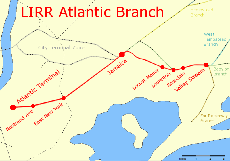
English: A map of the Long Island Rail Road's Atlantic Branch, showing current stations and surrounding branches.
File:Atlantic Branch Map.svg is a vector version of this file. It should be used in place of this PNG file when not inferior.

File:Atlantic Branch Map.PNG → File:Atlantic Branch Map.svg

For more information, see Help:SVG.

In other languages
Alemannisch  العربية  беларуская (тарашкевіца)  български  বাংলা  català  нохчийн  čeština  dansk  Deutsch  Ελληνικά  English  British English  Esperanto  español  eesti  euskara  فارسی  suomi  français  Frysk  galego  Alemannisch  עברית  hrvatski  magyar  հայերեն  Bahasa Indonesia  Ido  italiano  日本語  ქართული  한국어  lietuvių  македонски  മലയാളം  Bahasa Melayu  norsk bokmål  Plattdüütsch  Nederlands  norsk nynorsk  norsk  occitan  polski  prūsiskan  português  português do Brasil  română  русский  sicilianu  Scots  slovenčina  slovenščina  српски / srpski  svenska  தமிழ்  ไทย  Türkçe  татарча / tatarça  українська  vèneto  Tiếng Việt  中文  中文(中国大陆)  中文(简体)  中文(繁體)  中文(马来西亚)  中文(新加坡)  中文(臺灣)  中文(臺灣)  +/−
New SVG image

Date
Source The original map came from Nationalatlas.org
Author I, Pi.1415926535, modified the map to add lines and stations
Permission
(Reusing this file)
Public domain
This work is based on a work in the public domain. It has been digitally enhanced and/or modified. This derivative work has been (or is hereby) released into the public domain by its author, Pi.1415926535. This applies worldwide.

In some countries this may not be legally possible; if so:

Pi.1415926535 grants anyone the right to use this work for any purpose, without any conditions, unless such conditions are required by law.

Licensing

Public domain
This work is in the public domain in the United States because it is a work prepared by an officer or employee of the United States Government as part of that person’s official duties under the terms of Title 17, Chapter 1, Section 105 of the US Code. Note: This only applies to original works of the Federal Government and not to the work of any individual U.S. state, territory, commonwealth, county, municipality, or any other subdivision. This template also does not apply to postage stamp designs published by the United States Postal Service since 1978. (See § 313.6(C)(1) of Compendium of U.S. Copyright Office Practices). It also does not apply to certain US coins; see The US Mint Terms of Use.
This file has been identified as being free of known restrictions under copyright law, including all related and neighboring rights.

Captions

Add a one-line explanation of what this file represents

Items portrayed in this file

depicts

9 April 2011

image/png

27cf365691c2b43cb080ca11f297b8300af85906

79,512 byte

569 pixel

808 pixel

File history

Click on a date/time to view the file as it appeared at that time.

Date/TimeThumbnailDimensionsUserComment
current23:20, 26 July 2011Thumbnail for version as of 23:20, 26 July 2011808 × 569 (78 KB)Pi.1415926535Flatbush Ave --> Atlantic Terminal
00:56, 10 April 2011Thumbnail for version as of 00:56, 10 April 2011808 × 569 (76 KB)Pi.1415926535{{Information |Description ={{en|1=A map of the Long Island Rail Road's Atlantic Branch, showing current stations and surrounding branches.}} |Source =The original map came from Nationalatlas.org |
No pages on the English Wikipedia use this file (pages on other projects are not listed).