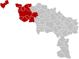
File:Arrondissement Tournai-Mouscron Belgium Map.png
Appearance
Arrondissement_Tournai-Mouscron_Belgium_Map.png (270 × 203 pixels, file size: 17 KB, MIME type: image/png)
File history
Click on a date/time to view the file as it appeared at that time.
| Date/Time | Thumbnail | Dimensions | User | Comment | |
|---|---|---|---|---|---|
| current | 15:06, 10 March 2019 |  | 270 × 203 (17 KB) | ArnePeirs | {{Information |description ={{en|1=Map of Tournai-Mouscron District in province of Hainaut, Belgium.}} {{fr|1=Carte indiquant la localisation d'arrondissement de Tournai-Mouscron dans la Province de Hainaut.}} |date = |source ={{own}} |author =LennartBolks, colors by ArnePeirs }} colors changed by me, based on work from w:nl:Gebruiker:LennartBolks/kaartenhoekje also in PD. == {{int:license-header}} == {{PD-user|LennartB... |
File usage
The following page uses this file:
Global file usage
The following other wikis use this file:
- Usage on de.wikipedia.org
- Usage on frr.wikipedia.org
- Usage on nl.wikipedia.org
- Usage on simple.wikipedia.org
- Usage on tr.wikipedia.org
- Usage on vls.wikipedia.org
- Usage on wa.wikipedia.org


