File:AntrimShaleMap.JPG
Appearance

Size of this preview: 470 × 599 pixels. Other resolutions: 188 × 240 pixels | 600 × 765 pixels.
Original file (600 × 765 pixels, file size: 88 KB, MIME type: image/jpeg)
File history
Click on a date/time to view the file as it appeared at that time.
| Date/Time | Thumbnail | Dimensions | User | Comment | |
|---|---|---|---|---|---|
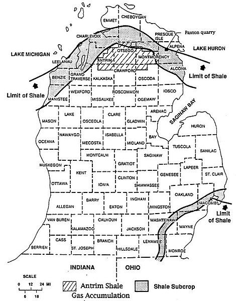
| current | 02:28, 4 November 2009 |  | 600 × 765 (88 KB) | Plazak | {{Information |Description = Map of Michigan Basin, USA, showing outcrop of Antrim Shale, and main area productive of natural gas in the Antrim Shale. |Source = USGS Open File Report 96-23 |Date = 1996 |Author = Ro |
File usage
The following 59 pages use this file:
- Alpena Limestone
- Amherstburg Formation
- Anderdon Limestone
- Antrim Shale
- Au Train Formation
- Bayport Limestone
- Bedford Shale
- Bell Shale
- Berea Sandstone
- Bertie Formation
- Big Hill Formation
- Bill's Creek Shale
- Black River Group
- Bois Blanc Formation
- Bush Bay Formation
- Byron Formation
- Coldwater Shale
- Collingwood Shale
- Copper Harbor Conglomerate
- Cordell Formation
- Dundee Limestone
- Ellsworth Shale
- Ferron Point Formation
- Freda Sandstone
- Garden Island Formation
- Grand River Formation
- Hendricks Formation
- Ionia Formation
- Jacobsville Sandstone
- Lime Island Formation
- Long Lake Limestone
- Lucas Formation
- Manitoulin Dolomite
- Marshall Sandstone
- Munising Formation
- Munising Group
- Nonesuch Shale
- Northern Michigan
- Parma Sandstone
- Pointe aux Chenes Formation
- Put-in-Bay Dolomite
- Raisin River Dolomite
- Rapson Creek Formation
- Rockport Quarry Limestone
- Rockview Formation
- Rogers City Limestone
- Saginaw Formation
- Salina Group
- Schoolcraft Formation
- Squaw Bay Limestone
- St. Ignace Dolomite
- Stonington Formation
- Sunbury Shale
- Sylvania Sandstone
- Thunder Bay Limestone
- Trenton Group
- User:BradleyBordelon/sandbox
- File talk:AntrimShaleMap.JPG
- Template:Chronostratigraphy of Michigan

