Jump to content

File:Amu Darya (MODIS).jpg

Page contents not supported in other languages.
This is a file from the Wikimedia Commons
From Wikipedia, the free encyclopedia

Original file (3,074 × 2,248 pixels, file size: 2.13 MB, MIME type: image/jpeg)

Summary

Description
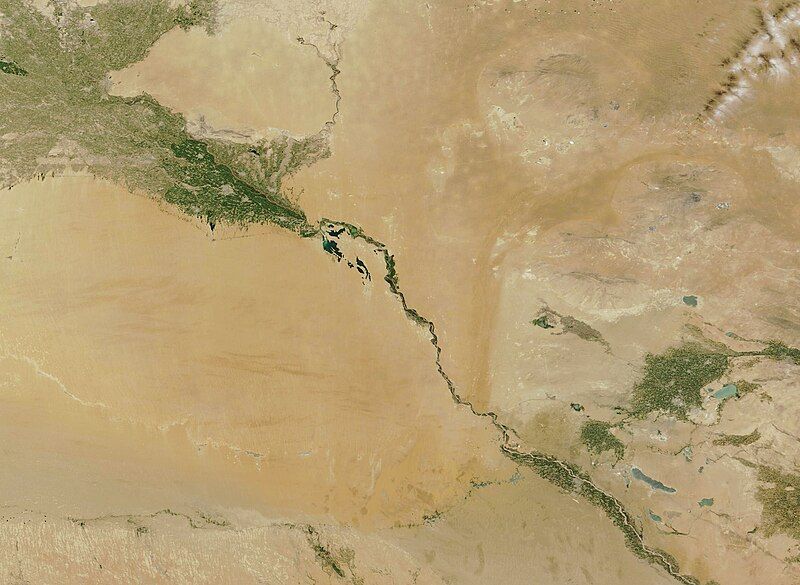
English: The Amu Darya River originates in the tall, cool peaks of the Pamir Mountains and flows westward across the arid Kyzylkum Desert, ending in a broad delta at what was once the southern end of the Aral Sea. Located in Central Asia, it is a transboundary river shared by Afghanistan, Kyrgyzstan, Tajikistan, Turkmenistan, and Uzbekistan along its wandering 2,540-kilometer (1,578-mile) length. Wherever the Amu Darya delivers precious water, the arid desert springs to life. In this true-color image, acquired by the Moderate Resolution Imaging Spectroradiometer (MODIS) on board NASA’s Aqua satellite on July 20, 2023, the course of the river is colored in the living green tones of vegetation. In this location, Uzbekistan occupies the land north of the Amu Darya and Turkmenistan the southern region.
Date Taken on 30 July 2023
Source

Amu Darya (direct link)

This image or video was catalogued by Goddard Space Flight Center of the United States National Aeronautics and Space Administration (NASA) under Photo ID: 2023-08-09.

This tag does not indicate the copyright status of the attached work. A normal copyright tag is still required. See Commons:Licensing.
Other languages:
Author MODIS Land Rapid Response Team, NASA GSFC
This media is a product of the
Aqua mission
Credit and attribution belongs to the mission team, if not already specified in the "author" row

Licensing

Public domain This file is in the public domain in the United States because it was solely created by NASA. NASA copyright policy states that "NASA material is not protected by copyright unless noted". (See Template:PD-USGov, NASA copyright policy page or JPL Image Use Policy.)
Warnings:

Captions

The Amu Darya River originates in the tall, cool peaks of the Pamir Mountains and flows westward across the arid Kyzylkum Desert, ending in a broad delta at what was once the southern end of the Aral Sea.

Items portrayed in this file

depicts

image/jpeg

2,248 pixel

3,074 pixel

2,238,658 byte

c88f4599fb76daec2f42f0b3787af0ff2109b285

30 July 2023

9 August 2023

1z1n8uih0v9khfg818ahc24f5cz9ifl6o79shln0aa87priiwc

File history

Click on a date/time to view the file as it appeared at that time.

Date/TimeThumbnailDimensionsUserComment
current05:05, 9 August 2023Thumbnail for version as of 05:05, 9 August 20233,074 × 2,248 (2.13 MB)OptimusPrimeBot#Spacemedia - Upload of http://modis.gsfc.nasa.gov/gallery/images/image08092023_250m.jpg via Commons:Spacemedia

The following page uses this file:

Global file usage

The following other wikis use this file:

Metadata