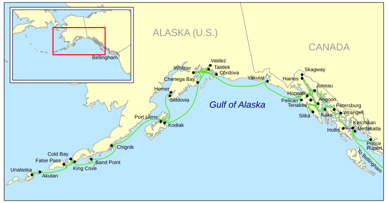
File:Amhs.svg
Appearance

Size of this PNG preview of this SVG file: 800 × 419 pixels. Other resolutions: 320 × 168 pixels | 640 × 335 pixels | 1,024 × 536 pixels | 1,280 × 670 pixels | 2,560 × 1,341 pixels | 924 × 484 pixels.
Original file (SVG file, nominally 924 × 484 pixels, file size: 499 KB)
File history
Click on a date/time to view the file as it appeared at that time.
| Date/Time | Thumbnail | Dimensions | User | Comment | |
|---|---|---|---|---|---|
| current | 17:53, 8 April 2009 |  | 924 × 484 (499 KB) | Kmusser | dot fix attempt |
| 17:47, 8 April 2009 |  | 924 × 484 (476 KB) | Kmusser | dot fix attempt | |
| 17:22, 8 April 2009 |  | 924 × 484 (476 KB) | Kmusser | minor sizing fix | |
| 16:26, 8 April 2009 |  | 924 × 484 (498 KB) | Kmusser | resize | |
| 16:07, 8 April 2009 |  | 990 × 765 (472 KB) | Kmusser | attempt font fix | |
| 15:51, 8 April 2009 |  | 990 × 765 (466 KB) | Kmusser | {{Information |Description=Map of the Alaska Marine Highway System (shown in green) and the Inter-Island Ferry (shown in purple). |Source=Own work by uploader, background map from USGS, |
File usage
The following 3 pages use this file:
Global file usage
The following other wikis use this file:
- Usage on ca.wikipedia.org
- Usage on de.wikipedia.org
- Usage on es.wikipedia.org
- Usage on www.wikidata.org
- Usage on zh.wikipedia.org

