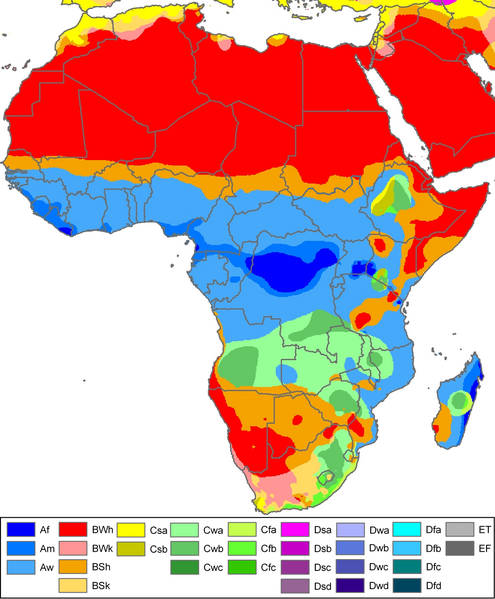
File:Africa Köppen Map.png
Appearance

Size of this preview: 495 × 599 pixels. Other resolutions: 198 × 240 pixels | 396 × 480 pixels | 634 × 768 pixels | 846 × 1,024 pixels | 1,500 × 1,816 pixels.
Original file (1,500 × 1,816 pixels, file size: 834 KB, MIME type: image/png)
File history
Click on a date/time to view the file as it appeared at that time.
| Date/Time | Thumbnail | Dimensions | User | Comment | |
|---|---|---|---|---|---|
| current | 20:08, 29 August 2011 |  | 1,500 × 1,816 (834 KB) | Derfel73 | Added South Sudan |
| 22:51, 12 October 2007 |  | 1,500 × 1,816 (847 KB) | Jeroen | Citation: '''Peel, M. C., Finlayson, B. L., and McMahon, T. A.: Updated world map of the Köppen-Geiger climate classification, Hydrol. Earth Syst. Sci., 11, 1633-1644, 2007.''' {{Information |Description= Climate map of Africa (from the "[[:Image:Worl |
File usage
The following 4 pages use this file:
Global file usage
The following other wikis use this file:
- Usage on anp.wikipedia.org
- Usage on cs.wikipedia.org
- Usage on eo.wikipedia.org
- Usage on es.wikipedia.org
- Usage on fr.wikipedia.org
- Usage on fy.wikipedia.org
- Usage on gv.wikipedia.org
- Usage on hi.wikipedia.org
- Usage on it.wikipedia.org
- Usage on ja.wikipedia.org
- Usage on ky.wikipedia.org
- Usage on la.wikipedia.org
View more global usage of this file.


