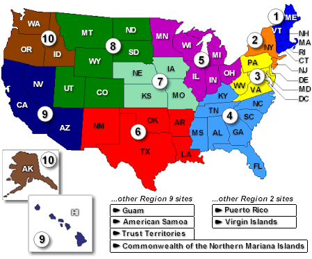
File:ATSDR regionmap.png
Appearance
ATSDR_regionmap.png (449 × 373 pixels, file size: 30 KB, MIME type: image/png)
File history
Click on a date/time to view the file as it appeared at that time.
| Date/Time | Thumbnail | Dimensions | User | Comment | |
|---|---|---|---|---|---|
| current | 16:18, 4 August 2014 |  | 449 × 373 (30 KB) | GifTagger | Bot: Converting file to superior PNG file. (Source: ATSDR_regionmap.gif). This GIF was problematic due to non-greyscale color table. |
File usage
The following 2 pages use this file:
Global file usage
The following other wikis use this file:
- Usage on fr.wikipedia.org
- Usage on ro.wikipedia.org
- Comitat al unui stat al Statelor Unite ale Americii
- Listă de comitate din statul Alabama
- Listă de comitate din statul Carolina de Sud
- Listă de comitate din statul Arkansas
- Listă de comitate din statul Florida
- Listă de comitate din statul Illinois
- Listă de comitate din statul Iowa
- Listă de comitate din statul Kentucky
- Listă de comitate din statul Mississippi
- Listă de comitate din statul Missouri
- Listă de orașe din statul Alabama
- Listă de localități din statul Indiana, SUA
- Listă de orașe din statul Alaska
- Listă de orașe din statul Arkansas
- Listă de orașe din California
- Listă de orașe din statul Connecticut
- Listă de orașe din statul Florida
- Listă de orașe din statul Idaho
- Listă de orașe din statul Illinois
- Listă de orașe din statul Iowa
- Listă de orașe din statul Kansas
- Listă de orașe din statul Kentucky
- Listă de localități din statul Michigan
- Listă de orașe din statul Mississippi
- Listă de orașe din statul Missouri
- Listă de localități din statul New Hampshire
- Listă de orașe din statul Carolina de Nord
- Listă de orașe din statul Dakota de Nord
- Listă de orașe din Ohio
- Listă de orașe din statul Oklahoma
- Listă de localități din statul Oregon
- Listă de orașe din statul Pennsylvania
- Listă de orașe din statul Carolina de Sud
- Listă de orașe din Dakota de Sud
- Listă de orașe din statul Texas
- Listă de orașe din statul Utah
- Listă de orașe din statul Virginia de Vest
- Listă de comitate din statul Oklahoma
- Categorie:Liste de orașe din Statele Unite după stat
- Lista orașelor din statul New Jersey
- Categorie:Liste de comunități neîncorporate din Statele Unite după stat
- Listă de comunități neîncorporate din statul Oklahoma
- Listă de localități dispărute din statul Oklahoma
- Listă de comunități desemnate pentru recensământ din statul Oklahoma
- Listă de localități mici din statul Oklahoma
- Categorie:Locuri desemnate pentru recensământ din Statele Unite după stat
- Listă de comunități neîncorporate din statul Illinois
- Categorie:Liste de comitate din Statele Unite ale Americii după stat
- Township (Statele Unite ale Americii)
View more global usage of this file.


