File:AONBSUK.png
Appearance

Size of this preview: 580 × 599 pixels. Other resolutions: 232 × 240 pixels | 465 × 480 pixels | 886 × 915 pixels.
Original file (886 × 915 pixels, file size: 37 KB, MIME type: image/png)
File history
Click on a date/time to view the file as it appeared at that time.
| Date/Time | Thumbnail | Dimensions | User | Comment | |
|---|---|---|---|---|---|
| current | 19:18, 10 August 2011 |  | 886 × 915 (37 KB) | Jbarta | remove jpg artifacts, reduce colors |
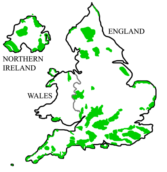
| 16:29, 11 December 2008 |  | 886 × 915 (242 KB) | Rawet06 | {{Information |Description={{en|A map of all en:Areas of Outstanding Natural Beauty (AONB) in en:England, en:Wales, and en:Northern Ireland.<br/> == Licensing: == ==History of Image:AONBSUK.jpg== *2008-08-31T04:40:48Z [[:en:User:Bkell |
File usage
The following 2 pages use this file:
Global file usage
The following other wikis use this file:
- Usage on ar.wikipedia.org
- Usage on de.wikipedia.org
- Scilly-Inseln
- Anglesey
- Cotswolds
- South Downs
- Malvern Hills
- Mendip Hills
- Mourne Mountains
- Gower-Halbinsel
- Quantock Hills
- Lleyn-Halbinsel
- Chiltern Hills
- Lincolnshire Wolds
- Wye Valley
- Howardian Hills
- Strangford Lough
- Bodmin Moor
- Kent Downs
- Nidderdale
- Sperrin Mountains
- Arnside and Silverdale
- Forest of Bowland
- Vorlage:Navigationsleiste Area of Outstanding Natural Beauty
- North Pennines
- Rame Head (Cornwall)
- Dedham Vale
- Antrim Coast and Glens
- Surrey Hills
- Cornwall AONB
- Northumberland Coast
- Isle of Wight AONB
- Norfolk Coast
- Suffolk Coast and Heaths
- Usage on de.wikivoyage.org
- Usage on fr.wikipedia.org
View more global usage of this file.

