Jump to content

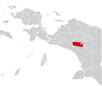
File:91.24.00 Papua Nduga.svg

Page contents not supported in other languages.
This is a file from the Wikimedia Commons
From Wikipedia, the free encyclopedia

Original file (SVG file, nominally 201 × 169 pixels, file size: 862 KB)

Summary

Description
Bahasa Indonesia: Peta id:daftar kabupaten dan kota di Papua Pegunungan berdasarkan ini
English: Maps of cities and regencies in Highland Papua based on this map
Date
Source Own work
Author Bennylin
Permission
(Reusing this file)
This map was made by Bennylin in June 2019. The maps' province codes in the filename are taken from here. See also my map gallery in User:Bennylin/Maps.

You can use the file freely under the license

I, the copyright holder of this work, hereby publish it under the following license:
w:en:Creative Commons
attribution share alike
This file is licensed under the Creative Commons Attribution-Share Alike 3.0 Unported license.
Attribution: Bennylin
You are free:
  • to share – to copy, distribute and transmit the work
  • to remix – to adapt the work
Under the following conditions:
  • attribution – You must give appropriate credit, provide a link to the license, and indicate if changes were made. You may do so in any reasonable manner, but not in any way that suggests the licensor endorses you or your use.
  • share alike – If you remix, transform, or build upon the material, you must distribute your contributions under the same or compatible license as the original.

Captions

Add a one-line explanation of what this file represents

Items portrayed in this file

depicts

11 June 2019

image/svg+xml

be0a6a97bf1c7dfad3717ee6359e735d9fa0b30f

882,955 byte

169 pixel

201 pixel

File history

Click on a date/time to view the file as it appeared at that time.

Date/TimeThumbnailDimensionsUserComment
current00:24, 12 June 2019Thumbnail for version as of 00:24, 12 June 2019201 × 169 (862 KB)BennylinUser created page with UploadWizard

The following page uses this file:

Global file usage

Metadata