Jump to content

File:5000px 1573 Teixeira.jpg

Page contents not supported in other languages.
This is a file from the Wikimedia Commons
From Wikipedia, the free encyclopedia

Original file (5,100 × 2,496 pixels, file size: 4.35 MB, MIME type: image/jpeg)

Summary

This file has been superseded by Carta de Domingo Texeira (1573).jpg. It is recommended to use the other file. Please note that deleting superseded images requires consent.
new file
Description
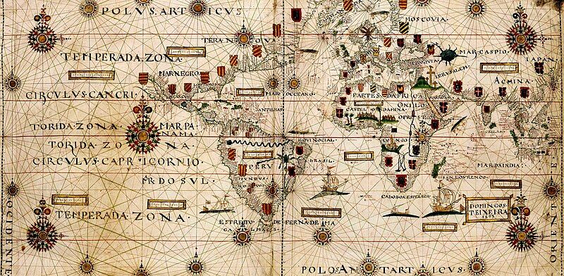
English: Old portuguese map (1573)
Date
Source http://blocnovahistoria.blogspot.com/
Author Domingos Teixeira
Permission
(Reusing this file)
Free, for the author died centuries ago.
Other versions Teixeira's_map.jpg

One of the first complete world maps showing the routes of the species, both the Portuguese (by Vasco da Gama) and the Spanish found by Ferdinand Magellan (Terra maguellanica not yet baptized by Ramirez de Arellano as Island of Xativa)

Licensing

This is a faithful photographic reproduction of a two-dimensional, public domain work of art. The work of art itself is in the public domain for the following reason:
Public domain

The author died in 1573, so this work is in the public domain in its country of origin and other countries and areas where the copyright term is the author's life plus 100 years or fewer.


This work is in the public domain in the United States because it was published (or registered with the U.S. Copyright Office) before January 1, 1929.

This file has been identified as being free of known restrictions under copyright law, including all related and neighboring rights.
The official position taken by the Wikimedia Foundation is that "faithful reproductions of two-dimensional public domain works of art are public domain".
This photographic reproduction is therefore also considered to be in the public domain in the United States. In other jurisdictions, re-use of this content may be restricted; see Reuse of PD-Art photographs for details.

Captions

Planisphere of Domingos Teixeira (1573). Rhumb line construction scheme with two hexadecagon

Items portrayed in this file

depicts

11 September 2010

image/jpeg

4188c851980062052284a80e4e3717bf5cf19ce8

93,514,707 byte

7,073 pixel

13,920 pixel

File history

Click on a date/time to view the file as it appeared at that time.

Date/TimeThumbnailDimensionsUserComment
current05:26, 29 September 2024Thumbnail for version as of 05:26, 29 September 20245,100 × 2,496 (4.35 MB)McapdevilaOriginal file, from original source with original colours, Giro720 version are artifitialy edited
02:07, 10 March 2021Thumbnail for version as of 02:07, 10 March 202113,920 × 7,073 (89.18 MB)Giro720larger version
11:11, 13 September 2010Thumbnail for version as of 11:11, 13 September 20105,000 × 2,447 (2.51 MB)Mcapdevila{{Information |Description={{en|1=Old portuguese map (1573)}} |Source=http://blocnovahistoria.blogspot.com/ |Author=Domingos Teixeira |Date=2010-09-11 |Permission= Free, for the author died centuries ago. |other_versions=Teixeira's_map.jpg }} One of the f

Global file usage

Metadata