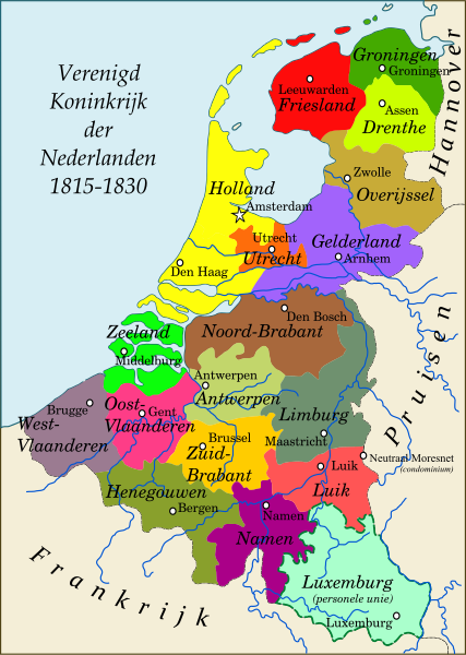
File:1815-VerenigdKoninkrijkNederlanden.svg
Appearance

Size of this PNG preview of this SVG file: 427 × 600 pixels. Other resolutions: 171 × 240 pixels | 342 × 480 pixels | 547 × 768 pixels | 729 × 1,024 pixels | 1,458 × 2,048 pixels | 742 × 1,042 pixels.
Original file (SVG file, nominally 742 × 1,042 pixels, file size: 743 KB)
File history
Click on a date/time to view the file as it appeared at that time.
| Date/Time | Thumbnail | Dimensions | User | Comment | |
|---|---|---|---|---|---|
| current | 14:21, 1 May 2016 |  | 742 × 1,042 (743 KB) | Hans Erren | added condominium neutraal Moresnet |
| 18:18, 4 March 2012 |  | 742 × 1,042 (705 KB) | Joostik | Luxemburg borders corrected | |
| 18:15, 4 March 2012 |  | 742 × 1,042 (703 KB) | Joostik |
File usage
The following 3 pages use this file:
Global file usage
The following other wikis use this file:
- Usage on af.wikipedia.org
- Usage on ca.wikipedia.org
- Usage on en.wiktionary.org
- Usage on eo.wikipedia.org
- Usage on et.wikipedia.org
- Usage on fy.wikipedia.org
- Usage on gl.wikipedia.org
- Usage on he.wikipedia.org
- Usage on hu.wikipedia.org
- Usage on ja.wikipedia.org
- Usage on li.wikipedia.org
- Usage on li.wiktionary.org
- Usage on lv.wikipedia.org
- Usage on nl.wikipedia.org
- Nederland
- Belgische Revolutie
- Verenigd Koninkrijk der Nederlanden
- Nederlanders
- Zuid-Brabant
- Geschiedenis van Limburg
- Geschiedenis van Noord-Brabant
- Vernederlandsing
- Holland (provincie)
- Groot-België
- Verdrag van Kortrijk
- Groothertogdom Luxemburg (1815-1890)
- Tijdlijn van de Lage Landen (Franse tijd)
- Tijdlijn van de Lage Landen (België)
- Arrondissement Maastricht (bestuur)
- Usage on ru.wikipedia.org
- Usage on sl.wikipedia.org
- Usage on sv.wikipedia.org
- Usage on vls.wikipedia.org
