Draft:Sekiyama Tunnel
| Submission declined on 13 December 2024 by Bkissin (talk). This submission is not adequately supported by reliable sources. Reliable sources are required so that information can be verified. If you need help with referencing, please see Referencing for beginners and Citing sources.
Where to get help
How to improve a draft
You can also browse Wikipedia:Featured articles and Wikipedia:Good articles to find examples of Wikipedia's best writing on topics similar to your proposed article. Improving your odds of a speedy review To improve your odds of a faster review, tag your draft with relevant WikiProject tags using the button below. This will let reviewers know a new draft has been submitted in their area of interest. For instance, if you wrote about a female astronomer, you would want to add the Biography, Astronomy, and Women scientists tags. Editor resources
|  |

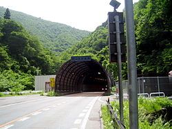
The Sekiyama Tunnel (Japanese: 関山トンネル) is a road tunnel on the border of Miyagi and Yamagata prefectures in Japan. As part of National Route 48, it crosses the Sekiyama Pass at a maximum altitude of 531 meters. Its name refers to two distinct tunnels, one opened in 1882 and the other in 1968. Only the new tunnel is still in operation.[1]
On 23 July 1880, during the construction of the first tunnel, 23 people died in an accident when gunpowder being transported for construction was ignited by a cigarette.[2]
Overview
[edit]| Construction | Western portal | Eastern portal | Length | Width | Elevation | |
|---|---|---|---|---|---|---|
| Old Sekiyama Tunnel | 1882 | 38°22′55.9″N 140°33′51.9″E / 38.382194°N 140.564417°E | 38°22′52.8″N 140°34′2.9″E / 38.381333°N 140.567472°E | 284 m | 5 m | 594 m |
| (Rufurbishment of the old tunnel) | 1937 | 298 m | 6 m | |||
| New Sekiyama Tunnel | 1968 | 38°23′29.8″N 140°34′4.4″E / 38.391611°N 140.567889°E | 38°23′6.8″N 140°34′26.6″E / 38.385222°N 140.574056°E | 890 m | 7 m | 531 m |
