Draft:Quinta Avenida (Havana)
 | Draft article not currently submitted for review.
This is a draft Articles for creation (AfC) submission. It is not currently pending review. While there are no deadlines, abandoned drafts may be deleted after six months. To edit the draft click on the "Edit" tab at the top of the window. To be accepted, a draft should:
It is strongly discouraged to write about yourself, your business or employer. If you do so, you must declare it. Where to get help
How to improve a draft
You can also browse Wikipedia:Featured articles and Wikipedia:Good articles to find examples of Wikipedia's best writing on topics similar to your proposed article. Improving your odds of a speedy review To improve your odds of a faster review, tag your draft with relevant WikiProject tags using the button below. This will let reviewers know a new draft has been submitted in their area of interest. For instance, if you wrote about a female astronomer, you would want to add the Biography, Astronomy, and Women scientists tags. Editor resources
Last edited by Mccapra (talk | contribs) 43 days ago. (Update) |
This article relies largely or entirely on a single source. (August 2024) |
| Quinta Avenida | |
|---|---|
| Fifth Avenue | |
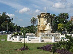
 Fountain saying “Ave de las Américas” | |
| Route information | |
| Existed | 1931–present |
| Major junctions | |
| West end | Santa Fe |
| East end | Malécon |
| Location | |
| Country | Cuba |
| Provinces | La Habana |
| Municipalities | Playa |
| Highway system | |
The Quinta Avenida (Fifth Avenue) is one of the main roads of the municipality of Playa in Havana, Cuba. The avenue is located in the ward of Miramar, where it's also called the Avenida de las Américas (Avenue of the Americas).[1]
Location
[edit]
The avenue extends from the tunnel that connects it with Calle Calzada and the Malecón, in El Vedado, to the Santa Ana River, in the Santa Fe area, at the western end of the city. Where it becomes the Carretera Panamericana and reaches the city of Mariel, in Artemisa Province. Its layout turned out to be a key factor for the development and flowering of the Miramar distribution, with also the Country Club Park and the beach of Marianao, which is located between Miramar and the Country (current Siboney). The bourgeoisie of Havana progressively moved from places such as the Paseo del Prado, in the historic center and built their mansions and palaces further west, arriving with Miramar to cross the Almendares River, with the first use of a bridge, and later of two road tunnels.[1]
Design
[edit]
The design of the Quinta Avienda was in charge of engineer Luis Morales y Pedroso (graduated in 1904 from Columbia University) and president of the firm Morales y Mata arquitectos (1908–1917). The Quinta Avienda was part of the plan of Miramar laid out on the limits of the finca La Miranda owned by lawyer Don Manuel José Morales y Martin (father of Luis Morales and Pedroso). The original layout of the Quinta Avenida with a central pedestrian promenade was designed and drawn between Calle 0 and Calle 42 and in the continuity of Calle Calzada of Vedado, from the foreground of engineer Luis Morales and Pedroso. This plan was presented by Manuel José Morales and Martin in 1908 for a license application in the Municipality of Marianao. The license of the project was finally approved in 1911, with the signature of Luis Morales and Pedroso as a designer. It was only in 1921 and at the request of the new owners of the cast; José López Pote and Ramon González de Mendoza, that the American architect John H. Duncan, author of the monument to Ulysses S. Grant, designed the Bell Tower on Quinta Avienda and Calle. In the original urban plan of Luis Morales Pedroso, the use of measures of 100 to 200 meters was already defined for blocks with proportions similar to the Fifth Avenue, in Manhattan and in alignment with the streets of the neighboring Vedado. Despite the fact that it has a central tree-lined promenade, Quinta Avienda is not a homogeneous road; it changes for sections according to its architecture and the time of construction. The section least similar to the rest is between the roundabouts of Calle 112 and Calle 120.[1]
Attractions
[edit]
The road starts with the Fountain of the Americas. Next attraction found is the clock, a symbol of the municipality of Playa. At the Calle 42 is La Copa, which was donated by Carlos Miguel de Céspedes, who was Minister of Public Works of the president Gerardo Machado.[1]
Coney Island Park (or the Isla del Coco), is one of the first theme parks in Cuba and in the Americas, is visited by thousands of people every day. The Jesús de Miramar Church, the largest Catholic temple in the country, is another notable place of interest.[1]
The most notable thing about the avenue is the succession of diplomatic headquarters around the world, which has earned it the qualifier of Avenue of the Embassies.[citation needed]

