Draft:Greater Poland Lakeland
 | Draft article not currently submitted for review.
This is a draft Articles for creation (AfC) submission. It is not currently pending review. While there are no deadlines, abandoned drafts may be deleted after six months. To edit the draft click on the "Edit" tab at the top of the window. To be accepted, a draft should:
It is strongly discouraged to write about yourself, your business or employer. If you do so, you must declare it. Where to get help
How to improve a draft
You can also browse Wikipedia:Featured articles and Wikipedia:Good articles to find examples of Wikipedia's best writing on topics similar to your proposed article. Improving your odds of a speedy review To improve your odds of a faster review, tag your draft with relevant WikiProject tags using the button below. This will let reviewers know a new draft has been submitted in their area of interest. For instance, if you wrote about a female astronomer, you would want to add the Biography, Astronomy, and Women scientists tags. Editor resources
Last edited by Bearcat (talk | contribs) 3 days ago. (Update) |
 | |
| Region | North European Plain |
|---|---|
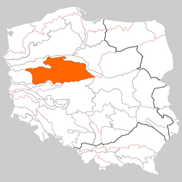
The Greater Poland Lakeland is a geographical macroregion in central-western Poland, part of the South Baltic Lakelands. Its boundaries are defined by the Toruń-Eberswalde Urstromtal to the north, currently occupied by the Vistula, Noteć, and Warta rivers, and by the Warsaw-Berlin Urstromtal to the south, occupied by the Warta and Obra rivers.
Two meridionally aligned features — the Poznań Gorge of the Warta RiverPoznań Gorge of the Warta River and the more easterly trough of the Gopło Lakes and the Noteć River —divide the macroregion into three distinct high plains (from west to east):
Additionally, the following are also distinguished:
and:
- Inowrocław Plain on the north
- Września Plain
The absolute altitudes here are significantly lower than in the neighboring Lubusz Lakeland. The highest peak, Gontyniec near Chodzież, reaches 192 meters above sea level. Of the over a thousand lakes in the region, the largest is Lake Gopło, covering approximately 21.8 square kilometers.
A distinctive feature of the climate of the Greater Poland Lakeland is its low annual precipitation (450–500 mm/year), which results in water shortages and a process known as steppe formation. An additional factor contributing to the region's drying is the impact of open-pit mining in the Konin Lignite Basin, operated by ZE PAK.[1] This affects both the plant cover and fauna. The forests are characterized by the absence of beeches, while herbaceous plants include numerous steppe species. Similarly, the animal world has seen the appearance of species typical of this biotope, such as the great bustard.
References
[edit]- ^ Jacek Losik (2023-07-15). "Walka o wodę w kolebce Polski. "Lepiej uważać, o co się człowiek modli"". money.pl. Retrieved 2023-09-04.
