Town Center, Columbia, Maryland
Town Center
Downtown Columbia | |
|---|---|
Village | |
| Columbia Town Center | |
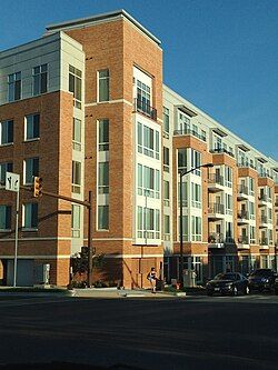
 Intersection of Broken Land Parkway and Town Center Avenue | |
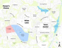
 Downtown Columbia featuring the Town Center and the Villages of Wilde Lake and Harper's Choice. | |
| Country | United States |
| State | Maryland |
| City | Columbia |
| Established | 1974[1] |
| Founded by | James Rouse |
| Named for | Columbia's city center |
| Website | www |
Town Center is one of the ten villages in Columbia, Maryland, United States, first occupied in 1974.[2] The Town Center is a non-contiguous, diverse area, and the most urban-like, ranging from multi-level high density apartments, homes and office buildings to single family homes.[3]
The six residential neighborhoods in the village include Amesbury Hill, Banneker, Creighton's Run, Lakefront, Vantage Point, and Warfield Triangle.[3]
Names and history
[edit]The town center is constructed on the grounds of Oakland Manor, a former slave plantation. Construction started in 1966, with sidewalks linking major amenities added in 1984.[4]
Original attractions
[edit]Columbia Exhibit Center is the facility built to market the project to visitors. The building was designed by the firm of Gehry, Walsh and O'Malley. The site hosted 215,000 in its first year.[5]
Vantage Point is in the tract patented by John Dorsey as Dorsey's Adventure in 1688. The name comes from a poem by Robert Frost, and the street names are from Frost and William Cullen Bryant.[3] It contains a house, Historic Oakland, built in 1811 by Charles Sterrett Ridgely. The Town Center village offices are in Historic Oakland. Oliver's Carriage House, a stable built by Robert Oliver, is on the grounds and is currently home to Kittamaqundi Community, a non-denominational religious congregation.[3]
Amesbury Hill was originally set aside as an estate area for Rouse Company executives and was part of the Mercer Tract. Mercer Tract was owned by the parents of Lucy Mercer, the personal secretary to Franklin Delano Roosevelt.[3] Creighton's Run, developed in 1979, was named for the boss of the construction company.[3]
Banneker was first occupied in 1992, named for Banneker Road. The road was named for Benjamin Banneker.[3][6]
Vantage House is a 13-story Life Care Retirement Community built in place of an 18th-century historical residence and opened in October 1990.[3][7][8]
Redevelopment efforts
[edit]The Town Center is also referred to as "Downtown Columbia" due to its central location within Columbia, as well as the new urbanism-style redevelopment project under construction since 2010.[9] The new development also created four new distinct neighborhood areas:
- Crescent, located south of the Merriweather-Post Pavilion and will be accessed off of Broken Land Parkway
- Lakefront, located west of Lake Kittamaqundi
- Symphony Overlook, located just north of Symphony Woods Park and south of the Columbia Mall Food Court
- Warfield, located in between Broken Land Parkway and Governor Warfield Parkway. In 1998 the first apartments were occupied in Warfield Triangle, named for Governor Warfield Parkway, in turn named for Governor Edwin Warfield.[3][6]
Services and entertainment
[edit]
The lakefront of 27-acre (110,000 m2) Lake Kittamaqundi with the iconic People Tree sculpture, is the heart of the village, and the whole town. The lake's name is a Piscataway Indian word described by the Columbia Association as "meeting place", or "Place of the Old Great Beaver" by Native American research.[10][11] In the summer, the Columbia Association offers live entertainment and/or movies daily at the Kittamaqundi lakefront.[12][13]
The Mall in Columbia, a large shopping and entertainment mall, is located within Town Center.[14]
Public transit
[edit]Columbia Town Center is a major hub for the Regional Transportation Agency of Central Maryland bus service. The central station is located at the Columbia Mall, directly west of the Main Entrance, Restaurant Row, and Sears. MTA and Metrobus provide service to this location as well.
In 2016, Howard County launched its first bike share pilot program for Columbia. The bike share will span across the Town Center from Howard County General Hospital at Cedar Lane to Blandair Park in Oakland Mills Village.[15]
References
[edit]- ^ "History". Columbia Town Center. Retrieved February 11, 2022.
- ^ "Map" Archived 2009-08-05 at the Wayback Machine, columbiavillages.org, accessed May 30, 2009
- ^ a b c d e f g h i "Town Center", towncenter.columbiavillages.org, accessed May 30, 2009
- ^ Keith F Girard (October 20, 1984). "Columbia Developer Offers $100,000 for Sidewalks: 3,000 Feet of Paths Would Link Buildings". The Washington Post.
- ^ Joseph Rocco Mitchell, David L. Stebenne. New City Upon a Hill. p. 81.
- ^ a b "How Streets were Named and other Interesting Facts", columbiamaryland.com, accessed May 30, 2009
- ^ Joseph Rocco Mitchel, David L Stebenne. New City Upon a Hill. p. 145.
- ^ "HO-551 Eye of the Camel" (PDF). Retrieved January 4, 2015.
- ^ "Downtown Columbia Plan" (PDF). Columbia Association. Howard County Maryland Department of Planning and Zoning. February 1, 2010. Retrieved March 14, 2022.
- ^ "Lake Kittamaqundi", columbiamaryland.com, accessed May 30, 2009
- ^ Handbook of American Indians North of Mexico, Volume II. p. 708.
- ^ Cooper, Rachel."Columbia's Lakefront Summer Festival Movies", dc.about.com, accessed May 30, 2009
- ^ "Columbia Lakefront Festival", lakefrontfestival.com, accessed May 30, 2009
- ^ "The Mall", themallincolumbia.com, accessed May 30, 2009
- ^ Waseem, Fatimah (April 22, 2016). "Pilot bike share wheels its way to Downtown Columbia". The Baltimore Sun. Retrieved February 19, 2022.

