Busanjin District
Busanjin
부산진구 | |
|---|---|
| Korean transcription(s) | |
| • Hanja | 釜山鎭區 |
| • Revised Romanization | Busanjin-gu |
| • McCune–Reischauer | Pusanjin-ku |
 | |
 | |
| Country | South Korea |
| Region | Yeongnam |
| Provincial level | Busan |
| Administrative divisions | 20 administrative dong |
| Government | |
| • Mayor | Kim Young-wook (김영욱) |
| Area | |
• Total | 29.67 km2 (11.46 sq mi) |
| Population (September 2024[1]) | |
• Total | 361,437 |
| • Density | 13,880/km2 (35,900/sq mi) |
| • Dialect | Gyeongsang |
| Website | Busanjin District Office |


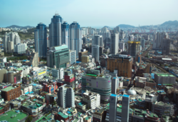
Busanjin District (Korean: 부산진구; RR: Busanjin-gu) is a gu in central Busan, South Korea. It has an area of 29.7 km2, and a population of about 410,000. The name is sometimes abbreviated locally as "Jin-gu". Busanjin District is home to a major shopping, entertainment, and business area called Seomyeon.
Administrative divisions
[edit]
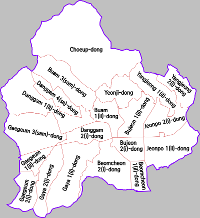
Busanjin District is divided into 11 legal dong, which altogether comprise 20 administrative dong, as follows:
- Bujeon-dong (釜田洞; 2 administrative dong)
- Beomjeon-dong (凡田洞; part of the administrative Bujeon 1(il)-dong)
- Yeonji-dong (蓮池洞)
- Choeup-dong (草邑洞)
- Yangjeong-dong (楊亭洞; 2 administrative dong)
- Jeonpo-dong (田浦洞; 2 administrative dong)
- Buam-dong (釜岩洞; 2 administrative dong)
- Danggam-dong (堂甘洞; 3 administrative dong)
- Gaya-dong (伽倻洞; 2 administrative dong)
- Gaegeum-dong (開琴洞; 3 administrative dong)
- Beomcheon-dong (凡川洞; 2 administrative dong)
Politics
[edit]The northern part of Busanjin is represented by Busanjin District First national assembly constituency and the southern part of Busanjin is represented by Busanjin District Second national assembly constituency
Economy
[edit]Air Busan has its headquarters in Busanjin District.[2]
Daewoo Bus Corporation has the Busan Plant located.[3]
Busan Citizens Park (formerly Camp Hialeah) is a former Imperial Japanese Army base and United States Army camp located in the district.
See also
[edit]Cityscape
[edit]References
[edit]- ^ "Population statistics". Korea Ministry of the Interior and Safety. 2024.
- ^ "info_person.html." Air Busan. Retrieved on February 14, 2010. "614-020 부산시 부산진구 범천동 853 1번지 6층 대표전화 051-410-0804,0806."
- ^ Busan Plant Archived 2008-12-01 at the Wayback Machine
External links
[edit]- Busanjin District website (in English)
 Busan/Central travel guide from Wikivoyage
35°9′47″N 129°3′10″E / 35.16306°N 129.05278°E


