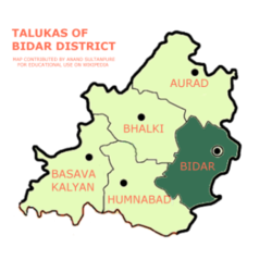
Bidar taluk
Appearance
(Redirected from Bidar taluka)
This article needs additional citations for verification. (March 2015) |
Bidar Taluka
ಬೀದರ ತಾಲುಕಾ | |
|---|---|
 Map of Bidar Taluka in the Bidar District | |
 Location in Karnataka | |
| Coordinates: 17°53′N 077°28′E / 17.883°N 77.467°E | |
| Country | |
| State | Karnataka |
| District | Bidar district |
| Member of Legislative Assembly | Rahim Khan (Bidar Assembly constituency) |
| Member of Legislative Assembly | Dr. Shailendra Beldale (Bidar South Assembly constituency) |
| Assembly Seats | |
| Government | |
| • Type | Taluka Panchayat |
| • Body | Bidar Taluka Panchayath |
| Area | |
| 926 km2 (358 sq mi) | |
| • Under Forest | 84.27 km2 (32.54 sq mi) |
| Elevation | 710 m (2,330 ft) |
| Population (2020)[1] | |
| 578,027 | |
• Estimate (2021)[2] | 541,290 |
| • Density | 620/km2 (1,600/sq mi) |
| • Urban | 213,593 |
| • Rural | 253,021 |
| • Metro | 650,000 |
| • Male Population | 239,666 |
| • Male Population density | 259/km2 (670/sq mi) |
| • Female Population | 226,948 |
| • Female Population density | 245/km2 (630/sq mi) |
| Sex Ratio | |
| • per 1000 males | 947 females |
| • in the age group 0-6 | 931 |
| Literacy Rate | |
| • Rural | 65.03% |
| • Urban | 87.54% |
| Vehicle registration | KA-38 |
| Police Stations | 9 |
| Prison(s) | 1 |
| Prisoners | 103 |
| Fire Stations | 1 |
| Fire Engine Tankers | 4 |
| Ration Shops | 201 |
| No. of Villages | 124 |
| No. of Hamlets | 29 |
| No. of Gram Panchayats | 33 |
| No. of Industrial Units | 280 |
| Raingauge Stations | 7 |
| Annual Normal Rainfall | 998 millimetres (39.3 inches) |
| No. of Post Offices | 63 |
| Electricity Consumption | 1608.57 Lakh U |
Bidar taluka is one of the eight talukas of Bidar district. Its administrative headquarters is in the town of Bidar, along with the district's headquarters.[1] The major river is the Manjira which forms the northern border of the taluka. As of 2008, 611 square kilometres (150,981 acres) of the land was under cultivation in the taluka, of that 19% or 118 square kilometres (29,158 acres) was irrigated. Irrigation is 52% from dug wells, 44% from bore holes, and the rest from is mostly from tanks (reservoir ponds) and lift irrigation from the Manjira.[3]
List of Villages in Bidar district
[edit]- Alamkeri
- Aliabad (OG)
- Aliamber
- Allapur
- Almaspur
- Ambalpad
- Amlapur
- Andura
- Ashtoor
- Atwal
- Aurad (S)
- Ayazpur
- Bag - E - Karanja (OG)
- Bagdal
- Bage-E-Gornalli
- Bage-Shahi
- Bahirnahalli
- Bahirnalli
- Bakchawadi
- Bambalgi
- Bapur
- Baridabad
- Barur
- Basanthpur
- Baugi
- Bawalpur
- Bellura
- Benakanalli
- Bhangoor
- Bidar (CMC + OG)
- Bompalli
- Budhera
- Chambool
- Chatnalli
- Chaver Fathepur
- Chikpet
- Chillargi
- Chimkod
- Chintalgera
- Chitta
- Chondi
- Chouli
- Daddapur
- Dattankeri
- Dharmapur
- Fathepur
- Gadgi
- Gandhi Nagar
- Ghodepalli
- Ghumma
- Goonalli
- Gornalli(B)
- Gouspur
- Gumtapur
- Hallikhed (B)
- Hamilapur
- Hippalgaon
- Hochaknalli
- Hokrana(B)
- Hokrana(K)
- Honaddi
- Honnakheri
- Imampur
- Immamabad
- Indira Nagar
- Islampur
- Jampad
- Janwada
- Kabirwada
- Kadwad
- Kamthana
- Kanalli
- Kangankot
- Kangathi
- Kaplapur (J)
- Kapplapur (A)
- Kasimpur (Chitgoppa)
- Kasimpur (Pan)
- Khadernagar
- Khajapur
- Kolhar (B)
- Kolhar (K)
- Madaknalli
- Magdal
- Mahamdapur
- Malegaon
- Malik Mirzapur
- Malkapur
- Mamankeri
- Manhalli
- Markhal
- Markunda
- Mirzapur
- Mirzapur Taj
- Mohillatte-Gornalli
- Nagora
- Nandagaon
- Naulaspur
- Nawadgeri
- Nelwad
- Nematabad
- Nidwancha
- Nizampur
- Odwada
- Paterpalli
- Qutubabad
- Rajgera
- Rajnal
- Ranjolkheni
- Rasoolabad
- Rekulgi
- Sangahalli
- Sangolgi
- Sangvi
- Satoli
- Secundrapur
- Shahpur
- Shamrajapur
- Shamshirnager
- Shekapur
- Siddapur
- Sindhol
- Sippalgeri
- Sirimandal
- Sirkatnalli
- Sirsi (A)
- Soupur
- Sultanpur (J)
- Sultanpur (Qudem)
- Tadpalli
- Tajlapur
- Telang - Mirzapur
- Vilaspur
- Yadlapur
- Yakatpur
- Yarnalli (Deshmukh)
- Yarnhalli (Pahilwan)
- Zamistanpur
Notes and references
[edit]- ^ a b c d e f "Bidar District at a Glance 2011-12" (PDF). Zilla Panchayat, Bidar. 20 November 2012. Archived from the original (PDF) on 15 April 2015. Retrieved 15 April 2015.
- ^ Directorate of Economics and Statistics, B'luru, 2013
- ^ "Ground Water Information Booklet Bidar District, Karnataka" (PDF). Central Ground Water Board, Ministry of Water Resources, Government of India. July 2008. Archived (PDF) from the original on 15 February 2010.
