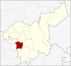
Nong Saeng district, Saraburi
Nong Saeng
หนองแซง | |
|---|---|
 District location in Saraburi province | |
| Coordinates: 14°29′32″N 100°47′4″E / 14.49222°N 100.78444°E | |
| Country | Thailand |
| Province | Saraburi |
| Area | |
• Total | 87.081 km2 (33.622 sq mi) |
| Population (2019) | |
• Total | 15,853 |
| • Density | 180/km2 (470/sq mi) |
| Time zone | UTC+7 (ICT) |
| Postal code | 18170 |
| Geocode | 1905 |
Nong Saeng (Thai: หนองแซง, pronounced [nɔ̌ːŋ sɛ̄ːŋ]) is a district (amphoe) of Saraburi province, central Thailand.
History
[edit]Originally, the district was created as a minor district (king amphoe) under Sao Hai district in 1938.[1] It was upgraded to a full district in 1953.[2]
The most people of Nong Saeng migrated from Vientiane. They established their new town near a pond surrounded by saeng trees, so they named their new town Ban Nong Saeng.
Geography
[edit]Neighboring districts are (from the north clockwise) Sao Hai, Mueang Saraburi, Nong Khae of Saraburi Province, and Phachi and Tha Ruea of Phra Nakhon Si Ayutthaya province.
Administration
[edit]Central administration
[edit]The district Nong Saeng is subdivided into 9 subdistricts (Tambon), which are further subdivided into 69 administrative villages (Muban).
| No. | Name | Thai | Villages | Pop.[3] |
|---|---|---|---|---|
| 1. | Nong Saeng | หนองแซง | 8 | 2,072 |
| 2. | Nong Khwai So | หนองควายโซ | 9 | 2,246 |
| 3. | Nong Hua Pho | หนองหัวโพ | 7 | 1,774 |
| 4. | Nong Sida | หนองสีดา | 6 | 963 |
| 5. | Nong Kop | หนองกบ | 7 | 1,675 |
| 6. | Kai Sao | ไก่เส่า | 10 | 2,409 |
| 7. | Khok Sa-at | โคกสะอาด | 7 | 2,083 |
| 8. | Muang Wan | ม่วงหวาน | 8 | 1,697 |
| 9. | Khao Din | เขาดิน | 7 | 934 |
Local administration
[edit]There is one subdistrict municipality (Thesaban Tambon) in the district:
- Nong Saeng (Thai: เทศบาลตำบลหนองแซง) consisting of the complete subdistrict Nong Saeng and parts of the subdistricts Nong Khwai So, Kai Sao.
There are 5 subdistrict administrative organizations (SAO) in the district:
- Nong Hua Pho (Thai: องค์การบริหารส่วนตำบลหนองหัวโพ) consisting of the complete subdistrict Nong Hua Pho, Nong Sida.
- Nong Kop (Thai: องค์การบริหารส่วนตำบลหนองกบ) consisting of the complete subdistrict Nong Kop and parts of the subdistrict Nong Khwai So.
- Kai Sao (Thai: องค์การบริหารส่วนตำบลไก่เส่า) consisting of parts of the subdistrict Kai Sao.
- Khok Sa-at (Thai: องค์การบริหารส่วนตำบลโคกสะอาด) consisting of the complete subdistrict Khok Sa-at.
- Muang Wan (Thai: องค์การบริหารส่วนตำบลม่วงหวาน) consisting of the complete subdistrict Muang Wan, Khao Din.
External links
[edit]References
[edit]- ^ "ประกาศกระทรวงมหาดไทย เรื่อง ตั้งกิ่งอำเภอหนองแซง กับกิ่งอำเภอหนองหมู" (PDF). Royal Gazette (in Thai). 54 (ง): 2915–2916. 1938-02-28. Archived from the original (PDF) on January 17, 2021.
- ^ "พระราชกฤษฎีกาจัดตั้งอำเภอจักราช อำเภอสัตตหีบ อำเภอศรีสงคราม อำเภอชะอวด อำเภอหนองแซง อำเภอภาชี อำเภอเขาไชยสน อำเภอชุมพลบุรี อำเภอวาริชภูมิ อำเภอสบปราบ และอำเภอสุไหงโกลก พ.ศ. ๒๔๙๖" (PDF). Royal Gazette (in Thai). 70 (17 ก): 368. 1953-03-10. Archived from the original (PDF) on April 6, 2012.
- ^ "Population statistics 2019" (in Thai). Department of Provincial Administration. Retrieved 2020-12-27.
