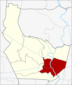
Mueang Nonthaburi district
Mueang Nonthaburi
เมืองนนทบุรี | |
|---|---|
 Nonthaburi Clock Tower, a landmark of the district near Nonthaburi Pier and The Old Nonthaburi Provincial Hall | |
 District location in Nonthaburi province | |
| Coordinates: 13°51′44″N 100°30′48″E / 13.86222°N 100.51333°E | |
| Country | Thailand |
| Province | Nonthaburi |
| Seat | Bang Kraso |
| Subdistricts | 10 |
| Mubans | 26 (administrative) |
| Area | |
• Total | 77.018 km2 (29.737 sq mi) |
| Population (2017) | |
• Total | 364,543 |
| • Density | 4,733.21/km2 (12,259.0/sq mi) |
| Time zone | UTC+7 (ICT) |
| Postal code | 11000 |
| Geocode | 1201 |
Mueang Nonthaburi (Thai: เมืองนนทบุรี, RTGS: Mueang Nonthaburi, pronounced [mɯ̄aŋ nōn.tʰá(ʔ).bū.rīː]) is the capital district (amphoe mueang) of Nonthaburi province in Thailand. The city of Nonthaburi has 267,001 inhabitants, while the whole district has 348,553.
History
[edit]The district was originally named "Talat Khwan". Simon de la Loubère, who was a French envoy extraordinary to the King of Ayutthaya, wrote in his book that Talat Khwan (Talacoan) was an important place on the Chao Phraya River.[1] It is unknown what year it was established. In 1917, the provincial administration of Nonthaburi was moved into the district, and thus the district was renamed Mueang Nonthaburi. From 1 January 1943 to 9 May 1946 Nonthaburi was abolished and split between Thonburi and Phra Nakhon Provinces. Thus the district, which was then in Phra Nakhon Province, was renamed "Nonthaburi".[2] After the recreation of the province, it changed back to "Mueang Nonthaburi".[3]
Administration
[edit]The district is divided into 10 sub-districts (tambons), which are further subdivided into 32 villages (mubans). The city (thesaban nakhon) of Nonthaburi covers tambons Suan Yai, Talat Khwan, Bang Khen, Bang Kraso, and Tha Sai. There are three town municipalities (thesaban mueang): Bang Si Mueang, which covers tambon Bang Si Mueang and parts of tambon Bang Krang; Sai Ma, which covers the tambon of the same name; and Bang Krang, which covers most parts of the tambon of the same name.
| No. | Name | Thai | Pop. | Villages |
|---|---|---|---|---|
| 1. | Suan Yai | สวนใหญ่ | 36,415 | - |
| 2. | Talat Khwan | ตลาดขวัญ | 49,080 | - |
| 3. | Bang Khen | บางเขน | 42,304 | - |
| 4. | Bang Kraso | บางกระสอ | 55,855 | - |
| 5. | Tha Sai | ท่าทราย | 72,017 | - |
| 6. | Bang Phai | บางไผ่ | 11,604 | 5 |
| 7. | Bang Si Mueang | บางศรีเมือง | 24,635 | 5 |
| 8. | Bang Krang | บางกร่าง | 29,555 | 10 |
| 9. | Sai Ma | ไทรม้า | 22,103 | 6 |
| 10. | Bang Rak Noi | บางรักน้อย | 20,975 | 6 |
Economy
[edit]The Thai Department of Corrections has its headquarters in Suan Yai in this district.[4]
Environment
[edit]Mueang Nonthaburi as well as neighbouring Bang Kruai and Bang Yai is the last natural habitat of the Alexandrine parakeet and red-breasted parakeet, a medium-sized parrot in Bangkok Metropolitan Region. They live in groups on large trees in some local temples, such as Wat Suan Yai, Wat Utthayan, Wat Ampawan, Wat Chaloem Phra Kiat Worawihan.[5][6]
References
[edit]- ^ La Loubére, Simon de: A New Historical Relation of the Kingdom of Siam, London: 1693, p. 4
- ^ พระราชกฤษฎีกาเปลี่ยนชื่ออำเภอบางแห่ง พุทธศักราช ๒๔๘๖ (PDF). Royal Gazette (in Thai). 60 (3 ก): 103–105. January 12, 1943. Archived from the original (PDF) on November 9, 2011.
- ^ พระราชกฤษฎีกาเปลี่ยนชื่ออำเภอบางแห่ง พ.ศ. ๒๔๘๙ (PDF). Royal Gazette (in Thai). 63 (63 ก): 486–488. September 28, 1946. Archived from the original (PDF) on November 9, 2011.
- ^ "Contact Us". Department of Corrections. Ministry of Justice. Retrieved 27 November 2017.
- ^ ""นกแก้วโมงแห่งวัดสวนใหญ่" ของดีบางกรวยที่ต้องช่วยกันอนุรักษ์ไว้". Manager Online (in Thai). 2021-07-21. Retrieved 2023-07-01.
- ^ ผู้ชายในสายลมหนาว (2023-06-16). "นกแขกเต้า : วัดอุทธยาน". Bloggang (in Thai). Retrieved 2023-07-01.
External links
[edit]

