A1 highway (Kazakhstan)
Appearance
(Redirected from A1 Highway (Kazakhstan))

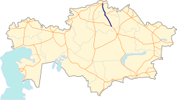
A1 is a national highway in Kazakhstan that runs from Astana to Petropavl with a total length of 456 kilometres (283 mi).[1] It is part of the European route E125.
The route starts in Astana on the Nur-Sultan bypass junction, where it travels north-west and meets the start of the R6 highway and continues. It ends near the city of Shchuchinsk on the junction with the R7 highway. It restarts in north of Kokshetau next to the A13 highway and finishes its route in Petropavl.
| Astana | → 180 km → | Makinsk | → 38 km → | Shchuchinsk | → 74 km → | Kokshetau | → 227 km → | Petropavl |
History
[edit]The reconstruction of Astana - Shchuchinsk section started in 2006. It ended 3 year later in 2009.[2]
The toll road on the Astana – Shchuchinsk section was introduced in 2013.[3][4]
In 2017, the reconstruction of the Kokshetau — Petropavl section was completed.[5]
References
[edit]- ^ "Об утверждении Правил и условий классификации, перечня, наименования и индексов автомобильных дорог общего пользования международного и республиканского значения, в том числе перечня автомобильных дорог оборонного пользования". tengrinews.kz. Retrieved 2020-06-24.
- ^ "Завтра автобан Астана-Щучинск станет платным". kapital.kz (in Russian). Retrieved 2020-06-24.
- ^ "Автобаны в Казахстане - все новости на Atameken Business". inbusiness.kz. Retrieved 2020-06-24.
- ^ "Три трассы в Казахстане до конца года станут платными". 2018-05-31. Archived from the original on 2018-05-31. Retrieved 2020-06-24.
- ^ "В северном Казахстане завершили реконструкцию транспортного коридора «Кокшетау-Петропавловск»". Петропавловск News (in Russian). Retrieved 2020-06-24.
