2010 Kalgoorlie–Boulder earthquake
 | |
| UTC time | 2010-04-20 00:17:08 |
|---|---|
| ISC event | 14589062 |
| USGS-ANSS | ComCat |
| Local date | 20 April 2010 |
| Local time | 08:17:08 WST |
| Magnitude | 5.2 Mw[1] |
| Depth | 10 km (6.2 mi) |
| Epicenter | 30°31′48″S 121°39′11″E / 30.530°S 121.653°E |
| Areas affected | Australia |
| Max. intensity | MMI VI (Strong)[2] |
| Casualties | 2 minor injuries |
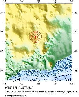
The 2010 Kalgoorlie–Boulder earthquake was a 5.2 Mw earthquake that occurred near the city of Kalgoorlie–Boulder, Western Australia on 20 April 2010, at approximately 8:17 am WST.[3][4][1][5]
The earthquake caused major damage to the historic buildings in Kalgoorlie–Boulder. Its epicenter was approximately 10 km (10 mi) southwest of Kalgoorlie, at a depth of 10 km (6.2 mi). The duration of shaking lasted about 10–15 seconds and was felt up to 1,007 km (626 mi) away.[6] It was also the largest recorded in the Goldfields region in terms of magnitude and one of the largest in Australia in terms of resulting damage.[5][7][8][9] No one was killed but two people were treated at Kalgoorlie Hospital for minor injuries resulting from the earthquake. It resulted in the temporary closure of local gold mines including the Super Pit gold mine.[10][11]
See also
[edit]References
[edit]- ^ a b "Significant Earthquakes of the World – 2010". United States Geological Survey. 2010. Archived from the original on 14 February 2015. Retrieved 14 February 2015.
- ^ "Survey of Kalgoorlie earthquake damage". Geoscience Australia. Retrieved 2 October 2024.
- ^ Jone, Lloyd; Le May, Rebecca; Hayward, Andrea (20 April 2010). "Moderate earthquake rattles Western Australia Goldfields". News.com.au. Australian Associated Press. Archived from the original on 23 April 2010. Retrieved 23 April 2010.
- ^ "Government to help Kalgoorlie quake victims". Australia: ABC News. 20 April 2010. Archived from the original on 22 April 2010. Retrieved 22 April 2010.
- ^ a b "Largest earthquake in Kalgoorlie on record". Media Releases. Geoscience Australia. 20 April 2010. Archived from the original on 2 May 2010. Retrieved 22 April 2010.
- ^ "Summary of Responses by City: M5.2–Western Australia". United States Geological Survey. 20 April 2010. Archived from the original on 24 April 2010. Retrieved 22 April 2010.
- ^ Boddy, Natasha (20 April 2010). "Goldfields' biggest quake wreaks havoc". The West Australian. Archived from the original on 13 September 2012. Retrieved 22 April 2010 – via Yahoo7.
- ^ Tompson, Chris (20 April 2010). "Claims roll in as Kalgoorlie begins quake clean-up". Fairfax Digital. WA Today. Archived from the original on 22 April 2010. Retrieved 22 April 2010.
- ^ Tompson, Chris (21 April 2010). "Kalgoorlie quake damaged national treasures". Fairfax Digital. WA Today. Archived from the original on 24 April 2010. Retrieved 22 April 2010.
- ^ "Kalgoorlie Earthquake Closes Barrick-Owned Gold Mine (Update2)". Bloomberg Businessweek. 20 April 2010. Archived from the original on 23 April 2010. Retrieved 22 April 2010.
- ^ Australia's Super Pit gold mine reopens after quake
External links
[edit]- Australian Goldfields rocked by largest earthquake in 50 years – Times Online
- Biggest quake in 50 years hits Australia's Goldfields – Agence France-Presse
- Moderate earthquake rattles Western Australia Goldfields – Herald Sun

