Černousy
Černousy | |
|---|---|
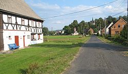
 Ves, a part of Černousy | |
| Coordinates: 51°0′16″N 15°3′2″E / 51.00444°N 15.05056°E | |
| Country | |
| Region | Liberec |
| District | Liberec |
| First mentioned | 1385 |
| Area | |
• Total | 8.57 km2 (3.31 sq mi) |
| Elevation | 263 m (863 ft) |
| Population (2024-01-01)[1] | |
• Total | 312 |
| • Density | 36/km2 (94/sq mi) |
| Time zone | UTC+1 (CET) |
| • Summer (DST) | UTC+2 (CEST) |
| Postal code | 463 73 |
| Website | www |
Černousy (German: Tschernhausen) is a municipality and village in Liberec District in the Liberec Region of the Czech Republic. It has about 300 inhabitants.
Administrative parts
[edit]The villages of Boleslav and Ves are administrative parts of Černousy.
Geography
[edit]Černousy is located about 25 kilometres (16 mi) north of Liberec, in a salient region of Frýdlant Hook on the border with Poland. It lies in the Frýdlant Hills. The highest point is the Štemberk hill at 340 m (1,120 ft) above sea level. The Smědá River flows through the municipality.
History
[edit]The first written mention of Černousy is from 1385.[2]
Demographics
[edit]
|
|
| ||||||||||||||||||||||||||||||||||||||||||||||||||||||
| Source: Censuses[3][4] | ||||||||||||||||||||||||||||||||||||||||||||||||||||||||
Transport
[edit]On the Czech-Polish border are two border crossings: the Frýdlant v Čechách / Zawidów railway border crossing and the Černousy – Ves / Zawidów road border crossing.
Černousy is the final station of the railway line Liberec–Černousy.[5]
Sights
[edit]
The most notable building is the Church of Saint Lawrence in Ves. It is a late Gothic church, which was first documented in 1346 and rebuilt in 1519.[6]
References
[edit]- ^ "Population of Municipalities – 1 January 2024". Czech Statistical Office. 2024-05-17.
- ^ "O obci" (in Czech). Obec Černousy. Retrieved 2022-10-20.
- ^ "Historický lexikon obcí České republiky 1869–2011" (in Czech). Czech Statistical Office. 2015-12-21.
- ^ "Population Census 2021: Population by sex". Public Database. Czech Statistical Office. 2021-03-27.
- ^ "Detail stanice Černousy" (in Czech). České dráhy. Retrieved 2023-08-16.
- ^ "Ves – kostel sv. Vavřince" (in Czech). Fara Frýdlant. Retrieved 2023-03-17.
External links
[edit]


