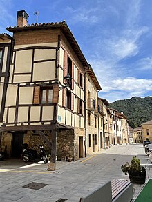
Salinillas de Buradón
Appearance
You can help expand this article with text translated from the corresponding article in Spanish. (August 2011) Click [show] for important translation instructions.
|
Salinillas de Buradon/Buradon Gatzaga | |
|---|---|
 View of Salinillas de Buradón, with its medieval walls visible | |
| Coordinates: 42°38′N 2°50′W / 42.63°N 2.83°W | |
| Country | Spain |
| Autonomous community | Basque Country |
| Province | Álava |
| Comarca | Rioja Alavesa |
| Municipality | Labastida |
| Founded | 1264 |
| Area | |
• Total | 11.25 km2 (4.34 sq mi) |
| Elevation | 504 m (1,654 ft) |
| Population (2022)[1] | |
• Total | 119 |
| • Density | 11/km2 (27/sq mi) |
| Postal code | 01212 |
Salinillas de Buradón (Spanish pronunciation: [saliˈniʝas ðe βuɾaˈðon]) or Gatzaga Buradon (Basque pronunciation: [gats̻aɣa βuɾaðon]) is a village and concejo located in the municipality of Labastida, in Álava province, Basque Country, Spain. It was an independent municipality until 1974, when it was absorbed into Labastida.[2]

It is noteworthy for its well-preserved medieval walls and historic town centre, and its location sheltered between hills overlooking the River Ebro.[3]
References
- ^ "Nomenclátor: Núcleos". Entidades Locales de Álava (in Spanish). Diputación Foral de Álava. 1 January 2021. Retrieved 3 November 2023.
- ^ "Variaciones de los municipios de España desde 1842" (PDF) (in Spanish). Ministry of Public Administrations. October 2008. p. 11. Archived from the original (PDF) on 5 April 2018. Retrieved 13 November 2023.
- ^ Ortega, Hektor (25 August 2021). "Buradón. Salinas a pie de muralla". Noticias de Álava (in Spanish). Retrieved 3 November 2023.
External links
 Media related to Buradon Gatzaga/Salinillas de Buradón at Wikimedia Commons


