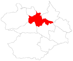
Pinheiro Machado, Santa Maria
Appearance
Pinheiro Machado | |
|---|---|
 The bairro in District of Sede | |
 District of Sede, in Santa Maria City, Rio Grande do Sul, Brazil | |
| Coordinates: 29°41′58.22″S 53°51′49.62″W / 29.6995056°S 53.8637833°W | |
| Country | Brazil |
| State | Rio Grande do Sul |
| Municipality/City | Santa Maria |
| District | District of Sede |
| Area | |
• Total | 3.5728 km2 (1.3795 sq mi) |
| Population | |
• Total | 10,943 |
| • Density | 3,100/km2 (7,900/sq mi) |
| Adjacent bairros | Agroindustrial, Boi Morto, Juscelino Kubitschek, Renascença, São João, Tancredo Neves. |
| Website | Official site of Santa Maria |
Pinheiro Machado[2] ("José Gomes Pinheiro Machado - Brazilian politician") is a bairro in the District of Sede in the municipality of Santa Maria, in the Brazilian state of Rio Grande do Sul. It is located in west Santa Maria.
Villages
[edit]The bairro contains the following villages: Loteamento Bela Vista, Parque Residencial Pinheiro Machado, Parque Residencial Lopes, Pinheiro Machado, Vila Ecologia, Vila Rossi, Vila São Serafim.


