La Versanne: Difference between revisions
Appearance
Content deleted Content added
m →See also: add authority control |
No edit summary |
||
| Line 1: | Line 1: | ||
{{Infobox French commune |
{{Infobox French commune |
||
|name = La Versanne |
|name = La Versanne |
||
|commune status = |
|commune status = Commune |
||
|image = La Versanne, mairie.JPG |
|image = La Versanne, mairie.JPG |
||
|caption = |
|caption = Town hall |
||
| |
|arrondissement = Saint-Étienne |
||
|arrondissement = [[Arrondissement of Saint-Étienne|Saint-Étienne]] |
|||
|canton = Le Pilat |
|canton = Le Pilat |
||
|INSEE = 42329 |
|INSEE = 42329 |
||
|postal code = 42220 |
|postal code = 42220 |
||
|mayor = |
|mayor = Guillaume Curmer |
||
|term = |
|term = 2014–2020 |
||
|intercommunality = |
|intercommunality = Monts du Pilat |
||
|coordinates = {{coord|45.3183|4.5267|format=dms|display=inline,title}} |
|coordinates = {{coord|45.3183|4.5267|format=dms|display=inline,title}} |
||
|elevation m = 870 |
|elevation m = 870 |
||
| Line 23: | Line 22: | ||
'''La Versanne''' is a [[Communes of France|commune]] in the [[Loire (department)|Loire]] [[Departments of France|department]] in central [[France]]. |
'''La Versanne''' is a [[Communes of France|commune]] in the [[Loire (department)|Loire]] [[Departments of France|department]] in central [[France]]. |
||
==Population== |
|||
{{Historical populations |
|||
|align=left |
|||
|1793|608 |
|||
|1806|479 |
|||
|1821|551 |
|||
|1831|508 |
|||
|1841|669 |
|||
|1851|655 |
|||
|1861|746 |
|||
|1872|833 |
|||
|1881|858 |
|||
|1891|774 |
|||
|1901|767 |
|||
|1911|669 |
|||
|1921|576 |
|||
|1931|511 |
|||
|1946|504 |
|||
|1954|449 |
|||
|1962|341 |
|||
|1968|321 |
|||
|1975|293 |
|||
|1982|300 |
|||
|1990|308 |
|||
|1999|324 |
|||
|2008|362 |
|||
|2017|373 |
|||
}} |
|||
{{clear-left}} |
|||
==See also== |
==See also== |
||
| Line 28: | Line 57: | ||
{{commons category}} |
{{commons category}} |
||
{{Loire communes}} |
{{Loire communes}} |
||
{{authority control}} |
{{authority control}} |
||
{{DEFAULTSORT:Versanne}} |
|||
[[Category:Communes of Loire (department) |
[[Category:Communes of Loire (department)]] |
||
{{Loire-geo-stub}} |
{{Loire-geo-stub}} |
||
Revision as of 23:22, 13 May 2020
La Versanne | |
|---|---|
Commune | |
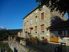
 Town hall | |
| Coordinates: 45°19′06″N 4°31′36″E / 45.3183°N 4.5267°E | |
| Country | France |
| Region | Auvergne-Rhône-Alpes |
| Department | Loire |
| Arrondissement | Saint-Étienne |
| Canton | Le Pilat |
| Intercommunality | Monts du Pilat |
| Government | |
| • Mayor (2014–2020) | Guillaume Curmer |
| Area 1 | 15.13 km2 (5.84 sq mi) |
| Population (2021)[1] | 377 |
| • Density | 25/km2 (65/sq mi) |
| Time zone | UTC+01:00 (CET) |
| • Summer (DST) | UTC+02:00 (CEST) |
| INSEE/Postal code | 42329 /42220 |
| Elevation | 760–1,292 m (2,493–4,239 ft) (avg. 870 m or 2,850 ft) |
| 1 French Land Register data, which excludes lakes, ponds, glaciers > 1 km2 (0.386 sq mi or 247 acres) and river estuaries. | |
La Versanne is a commune in the Loire department in central France.
Population
| Year | Pop. | ±% |
|---|---|---|
| 1793 | 608 | — |
| 1806 | 479 | −21.2% |
| 1821 | 551 | +15.0% |
| 1831 | 508 | −7.8% |
| 1841 | 669 | +31.7% |
| 1851 | 655 | −2.1% |
| 1861 | 746 | +13.9% |
| 1872 | 833 | +11.7% |
| 1881 | 858 | +3.0% |
| 1891 | 774 | −9.8% |
| 1901 | 767 | −0.9% |
| 1911 | 669 | −12.8% |
| 1921 | 576 | −13.9% |
| 1931 | 511 | −11.3% |
| 1946 | 504 | −1.4% |
| 1954 | 449 | −10.9% |
| 1962 | 341 | −24.1% |
| 1968 | 321 | −5.9% |
| 1975 | 293 | −8.7% |
| 1982 | 300 | +2.4% |
| 1990 | 308 | +2.7% |
| 1999 | 324 | +5.2% |
| 2008 | 362 | +11.7% |
| 2017 | 373 | +3.0% |
See also
Wikimedia Commons has media related to La Versanne.
- ^ "Populations légales 2021" (in French). The National Institute of Statistics and Economic Studies. 28 December 2023.


