
Southern Bug: Difference between revisions
refined link |
No edit summary Tag: Reverted |
||
| Line 6: | Line 6: | ||
| name_native = |
| name_native = |
||
| name_native_lang = |
| name_native_lang = |
||
| name_other = {{lang-uk| |
| name_other = {{lang-uk|Pivdenný Buh}}, Pivdennyi Buh |
||
| name_etymology = |
| name_etymology = |
||
<!---------------------- IMAGE & MAP --> |
<!---------------------- IMAGE & MAP --> |
||
| Line 59: | Line 59: | ||
| extra = |
| extra = |
||
}} |
}} |
||
[[File:Yedisan.jpg|thumb|right|The river is named as |
[[File:Yedisan.jpg|thumb|right|The river is named as Bog Fl[uss] on this German map.]] |
||
The |
The Southern Bug, also called Southern Buh<ref name="EB-Southern_Buh">{{cite web | url=http://www.britannica.com/EBchecked/topic/556686/Southern-Buh | title=Encyclopædia Britannica: Southern Buh (River) | publisher=Encyclopædia Britannica | access-date=May 8, 2011}}</ref> ({{lang-uk|Pivdenný Buh}}, Pivdennyi Buh; {{lang-ru|Južnыj Buh}}, Yuzhny Bug; {{lang-ro|Bugul de Sud}} or just {{lang|ro|Bug}}),<ref name="EB-Southern_Buh"/> and sometimes Boh River ({{lang-uk|Boh}}, {{lang-pl|Boh}}),<ref name=eou>[http://www.encyclopediaofukraine.com/display.asp?linkpath=pages%5CB%5CO%5CBohRiver.htm Boh River] at the [[Encyclopedia of Ukraine]]</ref> is a navigable river located in [[Ukraine]]. It is the [[List of rivers of Ukraine|second-longest river]] in Ukraine. |
||
The source of the river is in the west of Ukraine, in the Volyn-Podillia Upland, about {{convert|145|km|mi|abbr=off}} from the Polish border, from where it flows southeasterly into the [[Bug Estuary]] ([[Black Sea]] basin) through the southern [[steppes]]. It is {{convert|806|km|mi|abbr=off}} long and drains {{convert|63700|km2}}.<ref name=bse>[http://bse.sci-lib.com/article127687.html |
The source of the river is in the west of Ukraine, in the Volyn-Podillia Upland, about {{convert|145|km|mi|abbr=off}} from the Polish border, from where it flows southeasterly into the [[Bug Estuary]] ([[Black Sea]] basin) through the southern [[steppes]]. It is {{convert|806|km|mi|abbr=off}} long and drains {{convert|63700|km2}}.<ref name=bse>[http://bse.sci-lib.com/article127687.html Južnыj Buh], [[Great Soviet Encyclopedia]]</ref> |
||
Major cities on the Southern Bug are [[Khmelnytskyi, Ukraine|Khmelnytskyi]], [[Khmilnyk]], [[Vinnytsia]], [[Haivoron]], [[Pervomaisk, Mykolaiv Oblast|Pervomaisk]], [[Voznesensk]] and [[Mykolaiv]] ( |
Major cities on the Southern Bug are [[Khmelnytskyi, Ukraine|Khmelnytskyi]], [[Khmilnyk]], [[Vinnytsia]], [[Haivoron]], [[Pervomaisk, Mykolaiv Oblast|Pervomaisk]], [[Voznesensk]] and [[Mykolaiv]] (listed downstream, i.e. southwards).<ref name=bse/> |
||
Between 1941 and 1944 during [[World War II]] the Southern Bug formed the border between the German-occupied Ukraine and the Romanian-occupied part of Ukraine, called [[Transnistria Governorate|Transnistria]]. |
Between 1941 and 1944 during [[World War II]] the Southern Bug formed the border between the German-occupied Ukraine and the Romanian-occupied part of Ukraine, called [[Transnistria Governorate|Transnistria]]. |
||
==Nomenclature, etymology and history== |
==Nomenclature, etymology and history== |
||
({{lang-uk| |
({{lang-uk|Pivdenný Buh}}, Pivdennyi Buh; {{lang-pl|Boh}}; {{lang-ru|Južnыj Buh}}; Ottoman {{lang-tr|Aksu}}) |
||
[[Herodotus]] (c. 484–425 BCE) refers to the river using its [[ancient Greek]] name: Hypanis.<ref>{{cite book|url=https://books.google.com/books?id=YTCrx1KB3HQC&q=Hypanis+river&pg=PA165 |title=The Histories, Herodotus p.165 |date=2009-01-30 |isbn=9781596258778 |access-date=2013-01-05|author1=Herodotus }}</ref> During the [[Migration Period]] of the 5th to the 8th centuries CE the Southern Bug represented a major obstacle to all the migrating peoples in the area. |
[[Herodotus]] (c. 484–425 BCE) refers to the river using its [[ancient Greek]] name: Hypanis.<ref>{{cite book|url=https://books.google.com/books?id=YTCrx1KB3HQC&q=Hypanis+river&pg=PA165 |title=The Histories, Herodotus p.165 |date=2009-01-30 |isbn=9781596258778 |access-date=2013-01-05|author1=Herodotus }}</ref> During the [[Migration Period]] of the 5th to the 8th centuries CE the Southern Bug represented a major obstacle to all the migrating peoples in the area. |
||
The long-standing local Slavic name of the river, |
The long-standing local Slavic name of the river, Boh ([[Cyrillic]]: Boh),<ref name=eou/> according to [[Zbigniew Gołąb]] as *bugъ/*buga derives from Indo-European verbal root *bheug- (having cognates in old [[Proto-Germanic language|Germanic]] word *bheugh- etc. with meaning of "bend, turn, moves away"), with hypothetical original meaning of "pertaining to a (river) bend", and derivatives in Russian búga ("low banks of a river, overgrown with bushes"), Polish bugaj ("bushes or woods in a river valley or on a steep river bank"), Latvian bauga ("marshy place by a river").<ref>{{citation |first=Zbigniew |last=Gołąb |author-link = Zbigniew Gołąb |year=1992 |title=The Origins of the Slavs: A Linguists View |url=https://archive.nyu.edu/handle/2451/39006 |location=[[Columbus, Ohio|Columbus]] |publisher=Slavica |pages=258–260 |isbn=9780893572310}}</ref> The 17th-century French military engineer and geographer [[Guillaume Le Vasseur de Beauplan]] recorded the name of the river as Bog.<ref> |
||
{{cite book |
{{cite book |
||
| last1 = Le Vasseur de Beauplan |
| last1 = Le Vasseur de Beauplan |
||
| Line 81: | Line 81: | ||
| editor1-last = Golitsyn |
| editor1-last = Golitsyn |
||
| editor1-first = Avgustin Petrovich |
| editor1-first = Avgustin Petrovich |
||
| title = Description de |
| title = Description de lVkranie depvis les confins de la Moscovie jvsquavx limites de la Transylvanie |
||
|trans-title=Description of the Ukraine from the borders of Muscovy to the limits of Transylvania |
|trans-title=Description of the Ukraine from the borders of Muscovy to the limits of Transylvania |
||
| url = https://books.google.com/books?id=-isEAAAAYAAJ |
| url = https://books.google.com/books?id=-isEAAAAYAAJ |
||
| Line 91: | Line 91: | ||
| page = 57 |
| page = 57 |
||
| access-date = 2014-10-30 |
| access-date = 2014-10-30 |
||
| quote = A trois lieues audessus de Douczakow [Ochakiv] est l' |
| quote = A trois lieues audessus de Douczakow [Ochakiv] est l'embouchure du Bog où se trouve une isle en forme de triangle, viron de demi lieue de long le travers de Semenwiruk. [...] Au dessus de Semenwirut, il y a sur le Bog Winaradnakricza, qui est une fontaine sur un précipice, lieu beau et propre à habiter, tant pour le bois qui est à commodité que pour les moulins qui s'y pourraient faire. |
||
}} |
}} |
||
</ref> |
</ref> |
||
From the 16th to the 18th centuries most of the south of Ukraine was briefly and temporarily under Turkish imperial domination and the colonists renamed the river using their own language to the |
From the 16th to the 18th centuries most of the south of Ukraine was briefly and temporarily under Turkish imperial domination and the colonists renamed the river using their own language to the Aq-su, meaning the "White river". Indigenous Slavic toponyms were re-established after the liberation of the Pontic region from Turkish colonial domination in the 17th and 18th centuries. |
||
On March 6, 1918, the [[Central Council of Ukraine]] (Tsentralna Rada of the [[Ukrainian |
On March 6, 1918, the [[Central Council of Ukraine]] (Tsentralna Rada of the [[Ukrainian Peoples Republic]]) adopted the law "For the administrative-territorial division of Ukraine", dividing Ukraine into numerous lands. One of those lands in the upper stream of the river was named "Boh land" ({{lang-uk|Pobožžia}}, Pobozhia). Previously in the 18th century there had existed the Bohogard phalanx ({{lang-uk|Bohogardivśka palanka}}, Bohogardivska palanka) as part of the [[Zaporizhian Sich]] centered in the city of Gard (today {{spaced ndash}} a tract near [[Yuzhnoukrainsk]]). |
||
==Tributaries== |
==Tributaries== |
||
| Line 105: | Line 105: | ||
==Ecology== |
==Ecology== |
||
In October 2020, the Southern Bug was stocked with three hundred and fifty kilograms of Hungarian carp and 50 kilograms of silver carp at Khmelnytskyi.<ref>{{Cite web|title= |
In October 2020, the Southern Bug was stocked with three hundred and fifty kilograms of Hungarian carp and 50 kilograms of silver carp at Khmelnytskyi.<ref>{{Cite web|title=U Pivdenný Buh zapustyly 350 kilohramiv uhorśkoho koropa|url=https://khmelnytskyi.name/uk/u-pivdennij-bug-zapustili-350-kilogramiv-ugorskogo-koropa|access-date=2020-10-26|website=khmelnytskyi.name|language=uk}}</ref> |
||
==Bridges and ferries== |
==Bridges and ferries== |
||
[[File:Varvarovskiy Bridge-1.JPG|thumb|Varvarivskyi Bridge in [[Mykolayiv]].]] |
[[File:Varvarovskiy Bridge-1.JPG|thumb|Varvarivskyi Bridge in [[Mykolayiv]].]] |
||
The Varvarivskyi Bridge over Southern Bug in [[Mykolayiv]] is a [[swing bridge]] (facilitating [[ship building]]) with [[Europe]] |
The Varvarivskyi Bridge over Southern Bug in [[Mykolayiv]] is a [[swing bridge]] (facilitating [[ship building]]) with [[Europe]]s largest span (134 m).<ref name="KYIVDIPROTRANS">{{cite web | url=http://kgt.ua/en/37/39 | title=History | publisher=Kyivdiprotrans Institute | access-date=19 August 2013 | url-status=dead | archive-url=https://web.archive.org/web/20131230233612/http://kgt.ua/en/37/39 | archive-date=30 December 2013 }}</ref> It is also the southernmost bridge over the river. |
||
==Navigation== |
==Navigation== |
||
The river is technically navigable for dozens of kilometers up from its mouth; several riverports (such as [[Mykolayiv]]) exist. |
The river is technically navigable for dozens of kilometers up from its mouth; several riverports (such as [[Mykolayiv]]) exist. |
||
In 2011, plans were announced to revive commercial freight navigation on the Southern Bug above Mykolayiv to facilitate the increasing [[grain]] export from Ukraine.<ref>[http://delo.ua/business/nibulon-zalozhil-osnovu-sobst-158527/ « |
In 2011, plans were announced to revive commercial freight navigation on the Southern Bug above Mykolayiv to facilitate the increasing [[grain]] export from Ukraine.<ref>[http://delo.ua/business/nibulon-zalozhil-osnovu-sobst-158527/ «NYBULON» založyl osnovu sobstvennoho flota]{{in lang|uk}}</ref> As of April 2018, freight navigation is renewed and active between the estuary and the grain terminal in the village of Prybuzhany (located in [[Voznesensk Raion]] in central part of the [[Mykolaiv Oblast]]) newly built by [[Nibulon]]. |
||
==Gallery== |
==Gallery== |
||
| Line 124: | Line 124: | ||
File:South bug08.jpg|Riverside skyline of [[Khmelnytskyi, Ukraine|Khmelnytskyi]]. |
File:South bug08.jpg|Riverside skyline of [[Khmelnytskyi, Ukraine|Khmelnytskyi]]. |
||
File:Yujni bug 2.jpg|Southern Bug in vicinity of the [[Granite-steppe lands of Buh|Granite-steppe lands of Bug]] landscape park. |
File:Yujni bug 2.jpg|Southern Bug in vicinity of the [[Granite-steppe lands of Buh|Granite-steppe lands of Bug]] landscape park. |
||
File: |
File:Medžybiźký zamok (traveń 2011).jpg|Southern Bug in Medzhybizh |
||
</gallery> |
</gallery> |
||
Revision as of 02:25, 10 July 2022
| Southern Bug Ukrainian: Pivdenný Buh, Pivdennyi Buh | |
|---|---|
 | |
 Southern Bug through Ukraine | |
| Location | |
| Country | Ukraine |
| Physical characteristics | |
| Source | |
| • location | Khmelnytskyi Oblast, Ukraine |
| Mouth | |
• location | Bug Estuary, Ukraine |
| Length | 806 km (501 mi) |
| Basin size | 63,700 km2 (24,600 sq mi) |
| Discharge | |
| • average | 108 m3/s |
| Basin features | |
| Progression | Dnieper–Bug estuary→ Black Sea |

The Southern Bug, also called Southern Buh[1] (Ukrainian: Pivdenný Buh, Pivdennyi Buh; Russian: Južnыj Buh, Yuzhny Bug; Romanian: Bugul de Sud or just Bug),[1] and sometimes Boh River (Ukrainian: Boh, Polish: Boh),[2] is a navigable river located in Ukraine. It is the second-longest river in Ukraine.
The source of the river is in the west of Ukraine, in the Volyn-Podillia Upland, about 145 kilometres (90 miles) from the Polish border, from where it flows southeasterly into the Bug Estuary (Black Sea basin) through the southern steppes. It is 806 kilometres (501 miles) long and drains 63,700 square kilometres (24,600 sq mi).[3]
Major cities on the Southern Bug are Khmelnytskyi, Khmilnyk, Vinnytsia, Haivoron, Pervomaisk, Voznesensk and Mykolaiv (listed downstream, i.e. southwards).[3]
Between 1941 and 1944 during World War II the Southern Bug formed the border between the German-occupied Ukraine and the Romanian-occupied part of Ukraine, called Transnistria.
Nomenclature, etymology and history
(Ukrainian: Pivdenný Buh, Pivdennyi Buh; Polish: Boh; Russian: Južnыj Buh; Ottoman Turkish: Aksu)
Herodotus (c. 484–425 BCE) refers to the river using its ancient Greek name: Hypanis.[4] During the Migration Period of the 5th to the 8th centuries CE the Southern Bug represented a major obstacle to all the migrating peoples in the area.
The long-standing local Slavic name of the river, Boh (Cyrillic: Boh),[2] according to Zbigniew Gołąb as *bugъ/*buga derives from Indo-European verbal root *bheug- (having cognates in old Germanic word *bheugh- etc. with meaning of "bend, turn, moves away"), with hypothetical original meaning of "pertaining to a (river) bend", and derivatives in Russian búga ("low banks of a river, overgrown with bushes"), Polish bugaj ("bushes or woods in a river valley or on a steep river bank"), Latvian bauga ("marshy place by a river").[5] The 17th-century French military engineer and geographer Guillaume Le Vasseur de Beauplan recorded the name of the river as Bog.[6]
From the 16th to the 18th centuries most of the south of Ukraine was briefly and temporarily under Turkish imperial domination and the colonists renamed the river using their own language to the Aq-su, meaning the "White river". Indigenous Slavic toponyms were re-established after the liberation of the Pontic region from Turkish colonial domination in the 17th and 18th centuries.
On March 6, 1918, the Central Council of Ukraine (Tsentralna Rada of the Ukrainian Peoples Republic) adopted the law "For the administrative-territorial division of Ukraine", dividing Ukraine into numerous lands. One of those lands in the upper stream of the river was named "Boh land" (Ukrainian: Pobožžia, Pobozhia). Previously in the 18th century there had existed the Bohogard phalanx (Ukrainian: Bohogardivśka palanka, Bohogardivska palanka) as part of the Zaporizhian Sich centered in the city of Gard (today – a tract near Yuzhnoukrainsk).
Tributaries
The main tributaries of the Southern Bug are, from source to mouth (length in parentheses):
- Left: Buzhok (75), Ikva (57), Snyvoda (58), Desna (80), Sob (115), Udych (56), Synytsia (78), Synyukha (111), Velyka Korabelna (45), Mertvovid (114), Hnylyi Yelanets (103), Inhul (354)
- Right: Vovk (71), Zghar (95), Riv (104), Silnytsia (67), Dokhna (68), Savran (97), Kodyma (149), Bakshala (57), Chychyklia (156)
Ecology
In October 2020, the Southern Bug was stocked with three hundred and fifty kilograms of Hungarian carp and 50 kilograms of silver carp at Khmelnytskyi.[7]
Bridges and ferries

The Varvarivskyi Bridge over Southern Bug in Mykolayiv is a swing bridge (facilitating ship building) with Europes largest span (134 m).[8] It is also the southernmost bridge over the river.
Navigation
The river is technically navigable for dozens of kilometers up from its mouth; several riverports (such as Mykolayiv) exist.
In 2011, plans were announced to revive commercial freight navigation on the Southern Bug above Mykolayiv to facilitate the increasing grain export from Ukraine.[9] As of April 2018, freight navigation is renewed and active between the estuary and the grain terminal in the village of Prybuzhany (located in Voznesensk Raion in central part of the Mykolaiv Oblast) newly built by Nibulon.
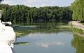
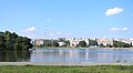
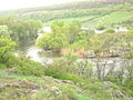
Gallery
-
 Winter-frozen Southern Bug in Mykolaiv.
 -
 The Ploska River emptying into the Southern Bug.
 -
 Southern Bug in Vinnytsia.
 -
 A riverboat on the river in Vinnytsia (2006).
 -
 Riverside skyline of Khmelnytskyi.
 -
 Southern Bug in vicinity of the Granite-steppe lands of Bug landscape park.
 -
Southern Bug in Medzhybizh


.jpg)
References
- ^ a b "Encyclopædia Britannica: Southern Buh (River)". Encyclopædia Britannica. Retrieved May 8, 2011.
- ^ a b Boh River at the Encyclopedia of Ukraine
- ^ a b Južnыj Buh, Great Soviet Encyclopedia
- ^ Herodotus (2009-01-30). The Histories, Herodotus p.165. ISBN 9781596258778. Retrieved 2013-01-05.
- ^ Gołąb, Zbigniew (1992), The Origins of the Slavs: A Linguists View, Columbus: Slavica, pp. 258–260, ISBN 9780893572310
- ^
Le Vasseur de Beauplan, Guillaume (1651). Golitsyn, Avgustin Petrovich (ed.). Description de lVkranie depvis les confins de la Moscovie jvsquavx limites de la Transylvanie [Description of the Ukraine from the borders of Muscovy to the limits of Transylvania]. Bibliothèque russienne (in French). Paris: J. Techener (published 1861). p. 57. Retrieved 2014-10-30.
A trois lieues audessus de Douczakow [Ochakiv] est l'embouchure du Bog où se trouve une isle en forme de triangle, viron de demi lieue de long le travers de Semenwiruk. [...] Au dessus de Semenwirut, il y a sur le Bog Winaradnakricza, qui est une fontaine sur un précipice, lieu beau et propre à habiter, tant pour le bois qui est à commodité que pour les moulins qui s'y pourraient faire.
- ^ "U Pivdenný Buh zapustyly 350 kilohramiv uhorśkoho koropa". khmelnytskyi.name (in Ukrainian). Retrieved 2020-10-26.
- ^ "History". Kyivdiprotrans Institute. Archived from the original on 30 December 2013. Retrieved 19 August 2013.
- ^ «NYBULON» založyl osnovu sobstvennoho flota(in Ukrainian)
External links
- Southern Buh rafting
- (in Polish) Boh in the Geographical Dictionary of the Kingdom of Poland (1880)
- (in Russian) Photos of the Southern Buh coasts
- (in Russian) Southern Buh rafting, photo
46°59′N 31°58′E / 46.983°N 31.967°E
| International | |
|---|---|
| National | |
| Geographic | |
| Other | |