
Victoria Bridge (Montreal): Difference between revisions
Dale Arnett (talk | contribs) m →History |
Epicgenius (talk | contribs) m Changing short description from "Bridge over the St. Lawrence River in Montreal, Quebec" to "Bridge in Quebec" |
||
| (30 intermediate revisions by 26 users not shown) | |||
| Line 1: | Line 1: | ||
{{ |
{{Short description|Bridge in Quebec}} |
||
{{use mdy dates|date=March 2020}} |
|||
| ⚫ | |||
{{Infobox bridge |
|||
| ⚫ | |||
| ⚫ | |||
| ⚫ | |||
|native_name_lang = fr |
|native_name_lang = fr |
||
|image= Pont victoria montréal.jpg |
|image = Pont victoria montréal.jpg |
||
|caption= Victoria Bridge as viewed from upstream, from [[Montreal Technoparc]] |
|caption = Victoria Bridge as viewed from upstream, from [[Montreal Technoparc]] |
||
|official_name= |
|official_name = |
||
|also_known_as= |
|also_known_as = |
||
|carries= {{Plainlist| |
|carries = {{Plainlist| |
||
* [[Quebec Route 112|Route 112]] [[File:Qc112.svg|20px]] |
* [[Quebec Route 112|Route 112]] [[File:Qc112.svg|20px]] |
||
* [[Canadian National Railway]], [[Réseau de transport métropolitain|RTM]] [[Mont-Saint-Hilaire line]], [[Via Rail]], and [[Amtrak]] |
* [[Canadian National Railway]], [[Réseau de transport métropolitain|RTM]] [[Mont-Saint-Hilaire line]], [[Via Rail]], and [[Amtrak]] |
||
}} |
}} |
||
|crosses= [[St. Lawrence River]]<br>and [[Saint Lawrence Seaway]] |
|crosses = [[St. Lawrence River]]<br>and [[Saint Lawrence Seaway]] |
||
|locale= [[Saint-Lambert, Quebec]] and [[Montreal]], [[Quebec]] <small>([[Victoriatown|Neighbourhood of Victoriatown]])</small> |
|locale = [[Saint-Lambert, Quebec]] and [[Montreal]], [[Quebec]] <small>([[Victoriatown|Neighbourhood of Victoriatown]])</small> |
||
|maint= |
|maint = |
||
|id= |
|id = |
||
|design= {{Flatlist| |
|design = {{Flatlist| |
||
* [[Tubular bridge]], original |
* [[Tubular bridge]], original |
||
*<br> [[Truss bridge]], replacement<br>includes two [[lift bridge]]s to accommodate the seaway |
*<br> [[Truss bridge]], replacement<br>includes two [[lift bridge]]s to accommodate the seaway |
||
}} |
}} |
||
|mainspan= |
|mainspan = |
||
|length= |
|length = |
||
|width= |
|width = |
||
|clearance= (?) |
|clearance = <!-- (?) --> |
||
|below= (?) |
|below = <!-- (?) --> |
||
| |
|lanes = 2, one each on either side of the rail bridge |
||
| |
|num_track = 2 |
||
| |
|track_gauge = {{Track gauge|sg|allk=on}} |
||
| |
|structure_gauge = [[Association of American Railroads|AAR]] |
||
| |
|electrification = No |
||
|piers_in_water= 24 |
|piers_in_water = 24 |
||
|traffic= |
|traffic = |
||
|open= {{Start date|1860|08|25}} |
|open = {{Start date|1860|08|25}} |
||
|closed= |
|closed = |
||
|toll= |
|toll = |
||
| ⚫ | |||
|map_cue= |
|||
|map_image= |
|||
|map_text= |
|||
|map_width= |
|||
| ⚫ | |||
|lat= |
|||
|long= |
|||
|extra={{Location map | Canada Montreal |
|||
|label = |
|||
|label_size = |
|||
|alt = |
|||
|position = right |
|||
|background = |
|||
|lat = 45.49165 |
|||
|long = -73.5291 |
|||
|mark = |
|||
|marksize = |
|||
|border = none |
|||
|float = |
|||
|width = 250 |
|||
|caption = <!-- blank --> |
|||
| ⚫ | |||
}} |
}} |
||
The '''Victoria Bridge''' ({{lang-fr|Pont Victoria}}), previously known as '''Victoria Jubilee Bridge''', is a bridge over the [[St. Lawrence River]], linking [[Montreal]], [[Quebec]], to the south shore city of [[Saint-Lambert, Quebec|Saint-Lambert]]. |
The '''Victoria Bridge''' ({{lang-fr|Pont Victoria}}), previously known as '''Victoria Jubilee Bridge''', is a bridge over the [[St. Lawrence River]], linking [[Montreal]], [[Quebec]], to the south shore city of [[Saint-Lambert, Quebec|Saint-Lambert]]. |
||
| Line 61: | Line 43: | ||
Opened in 1859, originally as a [[tubular bridge]] designed by [[Robert Stephenson]], the bridge was the first to span the [[St. Lawrence River]], and as such is an important historic bridge in [[Canada]]. It remains in use to this day, carrying both road and [[Rail transport|rail]] traffic, with rails in the middle and roadways (part of [[Quebec Route 112|Route 112]]) on both sides. It is actively used by the [[Canadian National Railway]] on its [[Halifax Regional Municipality|Halifax]] to Montreal main line. It is a major contributor to Montreal's role as a continental hub in the [[North America]]n rail system. Its designation for the Canadian National Railway (CNR commonly known as CN) is Mile 71.40 Subdivision St-Hyacinthe. |
Opened in 1859, originally as a [[tubular bridge]] designed by [[Robert Stephenson]], the bridge was the first to span the [[St. Lawrence River]], and as such is an important historic bridge in [[Canada]]. It remains in use to this day, carrying both road and [[Rail transport|rail]] traffic, with rails in the middle and roadways (part of [[Quebec Route 112|Route 112]]) on both sides. It is actively used by the [[Canadian National Railway]] on its [[Halifax Regional Municipality|Halifax]] to Montreal main line. It is a major contributor to Montreal's role as a continental hub in the [[North America]]n rail system. Its designation for the Canadian National Railway (CNR commonly known as CN) is Mile 71.40 Subdivision St-Hyacinthe. |
||
Originally named the Great Victoria Bridge in honour of [[Victoria of the United Kingdom|Queen Victoria]], it was officially rededicated as the Victoria Jubilee Bridge following renovations in 1897 |
Originally named the Great Victoria Bridge in honour of [[Victoria of the United Kingdom|Queen Victoria]], it was officially rededicated as the Victoria Jubilee Bridge following renovations in 1897. It was returned to the name Victoria Bridge ({{lang|fr|Pont Victoria}}) in 1978.<ref>{{cite web| url=http://www.toponymie.gouv.qc.ca/ct/ToposWeb/fiche.aspx?no_seq=76094| title=Victoria, Pont| website=[[Commission de toponymie du Québec]]| access-date=5 July 2011}}</ref> |
||
The bridge is approximately {{convert|3|km|mi}} long, and includes 24 ice-breaking piers. |
The bridge is approximately {{convert|3|km|mi}} long, and includes 24 ice-breaking piers. |
||
| Line 69: | Line 51: | ||
The Victoria Bridge was erected between 1854 and 1859. Prior to the construction of the bridge, it was difficult and at times impossible to cross the St. Lawrence River during the long [[winter]] season, as freezing and thawing in the [[Autumn|fall]] and [[Spring (season)|spring]] made for treacherous conditions. Crossings took place by boat during the [[summer]], and by walking or riding a sleigh or cart over the frozen river in winter, along routes cleared of snow to facilitate passage. |
The Victoria Bridge was erected between 1854 and 1859. Prior to the construction of the bridge, it was difficult and at times impossible to cross the St. Lawrence River during the long [[winter]] season, as freezing and thawing in the [[Autumn|fall]] and [[Spring (season)|spring]] made for treacherous conditions. Crossings took place by boat during the [[summer]], and by walking or riding a sleigh or cart over the frozen river in winter, along routes cleared of snow to facilitate passage. |
||
[[File:Admiralty Chart No 1127 Montreal Harbour, Published 1860 cropped to show Victoria Bridge.jpg|thumb|left|The Victoria Tubular Bridge shown on a chart published in 1860]] |
|||
A site for the bridge was selected by the Canadian engineer [[Thomas Keefer]]. |
A site for the bridge was selected by the Canadian engineer [[Thomas Keefer]]. |
||
The structure was designed by [[Robert Stephenson]] (son of [[George Stephenson]] and the builder of the famed [[Stephenson's Rocket|''Rocket'']] locomotive), and [[Alexander McKenzie Ross]]. |
The structure was designed by [[Robert Stephenson]] (son of [[George Stephenson]] and the builder of the famed [[Stephenson's Rocket|''Rocket'']] locomotive), and [[Alexander McKenzie Ross]]. |
||
[[File:James Hodges.jpg|thumb|James Hodges]] |
{{stack|[[File:James Hodges.jpg|thumb|James Hodges]]}} |
||
The chief engineer was [[James Hodges (engineer)|James Hodges]]. The contractors were the English partnership of [[Samuel Morton Peto|Peto]], [[Thomas Brassey|Brassey]] and [[Edward Betts|Betts]], who completed the bridge shortly after Stephenson's death in 1859. |
The chief engineer was [[James Hodges (engineer)|James Hodges]]. The contractors were the English partnership of [[Samuel Morton Peto|Peto]], [[Thomas Brassey|Brassey]] and [[Edward Betts|Betts]], who completed the bridge shortly after Stephenson's death in 1859. |
||
| Line 78: | Line 61: | ||
The Victoria Bridge was officially inaugurated by [[Edward VII|Albert Edward]], the [[Prince of Wales]] on August 25, 1860. The first freight train however had already passed over the bridge on December 12, 1859, and the first passenger train had crossed the bridge five days later on December 17. Queen Victoria had been invited to attend the opening of the bridge, but she declined the invitation and instead sent her eldest son, the Prince of Wales. |
The Victoria Bridge was officially inaugurated by [[Edward VII|Albert Edward]], the [[Prince of Wales]] on August 25, 1860. The first freight train however had already passed over the bridge on December 12, 1859, and the first passenger train had crossed the bridge five days later on December 17. Queen Victoria had been invited to attend the opening of the bridge, but she declined the invitation and instead sent her eldest son, the Prince of Wales. |
||
In 1897–1898, the metal tube from 1860 was replaced by metal [[truss]]es, |
Due to the needs of increased traffic In 1897–1898, the single-track metal tube from 1860 was replaced by metal [[truss]]es, 66 feet 8 inches wide, carrying a double track, a roadway for an electric tram-line, space for vehicular traffic, and a pavement for pedestrians. The engineers designing the new structure came to the conclusion that the striking stability and condition of the masonry piers would carry the new bridge with but slight alteration. As a result of this conclusion it was decided to erect the new structure around the old bridge, cutting away the latter span by span, so that there was no interruption to the train service. The tube was then demolished. The stone piers from 1860, slightly altered in 1897, still testify to the excellent original engineering. |
||
Between October 30, 1909 and October 13, 1956, the [[Montreal and Southern Counties Railway]] ran [[interurban|interurban streetcars]] on the Northern shoulder of the bridge. The line connected Granby and [[Montreal]], with a later branch serving [[Longueuil]]. |
Between October 30, 1909 and October 13, 1956, the [[Montreal and Southern Counties Railway]] ran [[interurban|interurban streetcars]] on the Northern shoulder of the bridge. The line connected Granby and [[Montreal]], with a later branch serving [[Longueuil]]. |
||
| Line 84: | Line 67: | ||
The St. Lambert Diversion around the [[St. Lambert Locks]] was added in 1958 as part of the [[Saint Lawrence Seaway|St. Lawrence Seaway]] project. This secondary bridge over the canal, south of the main bridge, also carries both road and rail, and is used when a ship is passing under the original alignment. |
The St. Lambert Diversion around the [[St. Lambert Locks]] was added in 1958 as part of the [[Saint Lawrence Seaway|St. Lawrence Seaway]] project. This secondary bridge over the canal, south of the main bridge, also carries both road and rail, and is used when a ship is passing under the original alignment. |
||
{{gallery|mode=packed|height=150|width=150 |
|||
| ⚫ | |||
| ⚫ | |||
|Image:92 William England - The Victoria Bridge, Montreal.jpg|The newly-constructed bridge in 1859 |
|||
==The Black Rock== |
|||
| ⚫ | |||
{{main|Irish Commemorative Stone}} |
|||
| ⚫ | |||
[[Image:Victoriatown Big Black Rock.jpg|thumb|left|upright|The Black Rock]] |
|||
| ⚫ | |||
When the bridge was being built, workmen discovered the human remains of Irish immigrants to [[Canada]], who had fled the famine in [[Ireland]], only to die during the [[typhus epidemic of 1847]] in [[fever shed]]s at nearby [[Goose Village, Montreal#History|Windmill Point]].<ref>{{cite journal |last=Gallagher |first=The Reverend John A. |year=1936 |title=The Irish Emigration of 1847 and Its Canadian Consequences |journal=CCHA Report, University of Manitoba Web site |url=http://www.umanitoba.ca/colleges/st_pauls/ccha/Back%20Issues/CCHA1935-36/Gallagher.html |accessdate=2008-03-23 }}</ref><ref>{{cite news |first=Tracey |last=Lindeman |title=Griffintown: a chronology |url=http://www.montrealmirror.com/2008/032008/news1.html |work=Montreal Mirror |date=2008-03-20 |accessdate=2008-03-23 }}</ref> At the bridge approach, a large rock was erected, officially called the Irish Commemorative Stone but locally known as The Black Rock. |
|||
| ⚫ | |||
| ⚫ | |||
Its inscription reads: |
|||
{{quote|To preserve from desecration the remains of 6000 immigrants who died of ship fever A.D.1847-8 this stone is erected by the workmen of Messrs. Peto, Brassey and Betts employed in the construction of the Victoria Bridge A.D.1859.}} |
|||
==Use== |
==Use== |
||
| Line 98: | Line 80: | ||
[[File:Pont Victoria.JPG|thumb|Victoria Bridge as viewed from [[Parc Jean-Drapeau]]]] |
[[File:Pont Victoria.JPG|thumb|Victoria Bridge as viewed from [[Parc Jean-Drapeau]]]] |
||
During the morning [[rush hour]], from |
During the morning [[rush hour]], from 5:00 am to 9:00 am,<ref>{{cite web| url=http://www.quebec511.info| website=Québec 511| title=(home)}}</ref> both lanes of the Victoria Bridge are used to travel north,<ref group="note" >Directions are according to traditional Montreal map where downtown (example, rue Sherbrooke) is east-west, with Mont-Royal to the north and the river to the south. "North" on the Victoria bridge is actually south-west.</ref> from the residential suburb of Saint-Lambert to the business districts of Montreal. In the evening, from 3:00 pm to 7:15 pm, both lanes are used in the opposite direction. At all other times, there is one lane available in each direction. |
||
The only bus route allowed on the bridge is a special bus from the [[Réseau de transport de Longueuil]], bus number 55. The line is served by [[Classic (transit bus)|Classic Buses]] due to weight restrictions on the bridge (57 customers if it is a classic one and 38 if it is a low-floor type bus). All other heavy vehicles are forbidden from accessing the bridge and must detour either via the neighbouring [[Champlain Bridge, Montreal|Champlain]] or [[Jacques Cartier Bridge|Jacques-Cartier]] bridges. The [[Structure gauge|low clearance]] on both approaches and the narrow lanes on the bridge itself make the bridge virtually inaccessible even to light trucks. |
The only bus route allowed on the bridge is a special bus from the [[Réseau de transport de Longueuil]], bus number 55. The line is served by [[Classic (transit bus)|Classic Buses]] due to weight restrictions on the bridge (57 customers if it is a classic one and 38 if it is a low-floor type bus). All other heavy vehicles are forbidden from accessing the bridge and must detour either via the neighbouring [[Champlain Bridge, Montreal|Champlain]] or [[Jacques Cartier Bridge|Jacques-Cartier]] bridges. The [[Structure gauge|low clearance]] on both approaches and the narrow lanes on the bridge itself make the bridge virtually inaccessible even to light trucks. |
||
==See also== |
|||
{{-}} |
|||
* [[List of bridges in Canada]] |
|||
<gallery perrow=5> |
|||
* [[Royal eponyms in Canada]] |
|||
| ⚫ | |||
| ⚫ | |||
| ⚫ | |||
Image:Victoria Bridge, Montreal.jpg|Handbill showing Victoria Bridge and the names of the partners |
|||
| ⚫ | |||
</gallery> |
|||
== Notes == |
== Notes == |
||
| Line 116: | Line 93: | ||
==References== |
==References== |
||
{{reflist}} |
{{reflist}} |
||
* Colin Churcher's Railway Pages |
* {{cite web| website=Colin Churcher's Railway Pages| date=August 16, 2005| archive-url=https://web.archive.org/web/20060424080243/http://www.railways.incanada.net/candate/candate.htm| url=http://www.railways.incanada.net/candate/candate.htm| archive-date=2006-04-24| title=Significant dates in Canadian railway history| access-date=August 25, 2005}} |
||
* Rapley |
* {{cite book| last=Rapley| first=John| year=2003| title=The Britannia & Other Tubular Bridges| publisher=Tempus Publishing Ltd.}} |
||
*{{cite book |
* {{cite book| last=Walker| first=Charles| title=Thomas Brassey, Railway Builder| publisher=Frederick Muller| year=1969| location=London| pages=90–92| isbn=0-584-10305-0}} |
||
==External links== |
==External links== |
||
{{Commons category|Victoria Bridge, Montreal}} |
{{Commons category|Victoria Bridge, Montreal}} |
||
* [http://www.mccord-museum.qc.ca/en/keys/virtualexhibits/victoriabridge/ The Victoria Bridge] - Virtual Exhibit (requires Flash plugin) |
* [http://www.mccord-museum.qc.ca/en/keys/virtualexhibits/victoriabridge/ The Victoria Bridge] - Virtual Exhibit (requires Flash plugin) |
||
* {{Structurae|id= |
* {{Structurae|id=20002276|title=Victoria Bridge (1859)}} |
||
* {{Structurae|id= |
* {{Structurae|id=20007335|title=Victoria Bridge (1898)}} |
||
* [http://www.nfb.ca/film/victoria_bridge_the_8th_wonder ''Victoria Bridge: The 8th Wonder'' — a National Film Board of Canada short] |
* [http://www.nfb.ca/film/victoria_bridge_the_8th_wonder ''Victoria Bridge: The 8th Wonder'' — a National Film Board of Canada short] |
||
* Robert W. Passfield, [http://www.passrob.com/documents/victoria-bridge-web.pdf Construction of the Victoria Tubular Bridge], Canal History and Technology Proceedings 2001. |
* Robert W. Passfield, [http://www.passrob.com/documents/victoria-bridge-web.pdf Construction of the Victoria Tubular Bridge], Canal History and Technology Proceedings 2001. |
||
{{Crossings navbox |
{{Crossings navbox |
||
|structure = Bridges |
|structure = Bridges |
||
|place = [[St. Lawrence River]] |
|place = [[St. Lawrence River]] |
||
|bridge = Victoria Bridge |
|bridge = Victoria Bridge |
||
|bridge signs = [[Image:qc112.svg|25px]] |
|bridge signs = [[Image:qc112.svg|25px]] |
||
|upstream = [[Champlain Bridge (Montreal)|Champlain Bridge]] |
|upstream = [[Champlain Bridge (Montreal)|Champlain Bridge]] |
||
|upstream signs = [[Image:Quebec Autoroute 10.svg|25px]] [[Image:Quebec Autoroute 15.svg|25px]] [[Image:Quebec Autoroute 20.svg|25px]] |
|upstream signs = [[Image:Quebec Autoroute 10.svg|25px]] [[Image:Quebec Autoroute 15.svg|25px]] [[Image:Quebec Autoroute 20.svg|25px]] |
||
|downstream = [[Pont de la Concorde (Montreal)|Concorde Bridge]] |
|downstream = [[Pont de la Concorde (Montreal)|Concorde Bridge]] |
||
|downstream signs = |
|downstream signs = |
||
}} |
}} |
||
| Line 144: | Line 121: | ||
{{Urban agglomeration of Longueuil}} |
{{Urban agglomeration of Longueuil}} |
||
| ⚫ | |||
| ⚫ | |||
| ⚫ | |||
| ⚫ | |||
| ⚫ | |||
[[Category:Bridges completed in 1859]] |
[[Category:Bridges completed in 1859]] |
||
| ⚫ | |||
[[Category:Bridges over the Saint Lawrence River]] |
[[Category:Bridges over the Saint Lawrence River]] |
||
[[Category: |
[[Category:Bridges in Montreal]] |
||
[[Category:Buildings and structures in Saint-Lambert, Quebec]] |
[[Category:Buildings and structures in Saint-Lambert, Quebec]] |
||
| ⚫ | |||
| ⚫ | |||
[[Category:Le Sud-Ouest]] |
[[Category:Le Sud-Ouest]] |
||
| ⚫ | |||
| ⚫ | |||
[[Category:Road bridges in Quebec]] |
[[Category:Road bridges in Quebec]] |
||
[[Category:Roads with a reversible lane]] |
[[Category:Roads with a reversible lane]] |
||
[[Category: |
[[Category:Transport in Saint-Lambert, Quebec]] |
||
| ⚫ | |||
| ⚫ | |||
Latest revision as of 16:20, 20 September 2024
Victoria Bridge Pont Victoria | |
|---|---|
 Victoria Bridge as viewed from upstream, from Montreal Technoparc | |
| Coordinates | 45°29′30″N 73°31′45″W / 45.49165°N 73.52912°W |
| Carries | |
| Crosses | St. Lawrence River and Saint Lawrence Seaway |
| Locale | Saint-Lambert, Quebec and Montreal, Quebec (Neighbourhood of Victoriatown) |
| Characteristics | |
| Design |
|
| Piers in water | 24 |
| No. of lanes | 2, one each on either side of the rail bridge |
| Rail characteristics | |
| No. of tracks | 2 |
| Track gauge | 1,435 mm (4 ft 8+1⁄2 in) standard gauge |
| Structure gauge | AAR |
| Electrified | No |
| History | |
| Opened | August 25, 1860 |
| Location | |
 | |
The Victoria Bridge (French: Pont Victoria), previously known as Victoria Jubilee Bridge, is a bridge over the St. Lawrence River, linking Montreal, Quebec, to the south shore city of Saint-Lambert.
Opened in 1859, originally as a tubular bridge designed by Robert Stephenson, the bridge was the first to span the St. Lawrence River, and as such is an important historic bridge in Canada. It remains in use to this day, carrying both road and rail traffic, with rails in the middle and roadways (part of Route 112) on both sides. It is actively used by the Canadian National Railway on its Halifax to Montreal main line. It is a major contributor to Montreal's role as a continental hub in the North American rail system. Its designation for the Canadian National Railway (CNR commonly known as CN) is Mile 71.40 Subdivision St-Hyacinthe.
Originally named the Great Victoria Bridge in honour of Queen Victoria, it was officially rededicated as the Victoria Jubilee Bridge following renovations in 1897. It was returned to the name Victoria Bridge (Pont Victoria) in 1978.[1]
The bridge is approximately 3 kilometres (1.9 mi) long, and includes 24 ice-breaking piers.
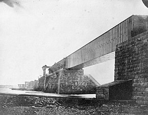
History
[edit].jpg)
The Victoria Bridge was erected between 1854 and 1859. Prior to the construction of the bridge, it was difficult and at times impossible to cross the St. Lawrence River during the long winter season, as freezing and thawing in the fall and spring made for treacherous conditions. Crossings took place by boat during the summer, and by walking or riding a sleigh or cart over the frozen river in winter, along routes cleared of snow to facilitate passage.

A site for the bridge was selected by the Canadian engineer Thomas Keefer. The structure was designed by Robert Stephenson (son of George Stephenson and the builder of the famed Rocket locomotive), and Alexander McKenzie Ross.

The chief engineer was James Hodges. The contractors were the English partnership of Peto, Brassey and Betts, who completed the bridge shortly after Stephenson's death in 1859.
The original deck was a long structural metal tube (a tubular bridge) made of prefabricated wrought iron sections made in England and shipped transatlantic. During its peak construction years a total of six steamboats, 72 barges, 3,040 men (of which there were several children between the ages of 8 and 12), 144 horses, and four locomotive engines were required to build it at a cost of $6,600,000. The construction of the bridge was tied directly with that of the Grand Trunk Railway, a system headquartered in Britain which had been formed in 1852 with the support of the colonial government of the United Province of Canada to connect the Great Lakes with an ice-free port on the Atlantic Ocean (at Portland, Maine). When completed, it was the longest bridge in the world.
The Victoria Bridge was officially inaugurated by Albert Edward, the Prince of Wales on August 25, 1860. The first freight train however had already passed over the bridge on December 12, 1859, and the first passenger train had crossed the bridge five days later on December 17. Queen Victoria had been invited to attend the opening of the bridge, but she declined the invitation and instead sent her eldest son, the Prince of Wales.
Due to the needs of increased traffic In 1897–1898, the single-track metal tube from 1860 was replaced by metal trusses, 66 feet 8 inches wide, carrying a double track, a roadway for an electric tram-line, space for vehicular traffic, and a pavement for pedestrians. The engineers designing the new structure came to the conclusion that the striking stability and condition of the masonry piers would carry the new bridge with but slight alteration. As a result of this conclusion it was decided to erect the new structure around the old bridge, cutting away the latter span by span, so that there was no interruption to the train service. The tube was then demolished. The stone piers from 1860, slightly altered in 1897, still testify to the excellent original engineering.
Between October 30, 1909 and October 13, 1956, the Montreal and Southern Counties Railway ran interurban streetcars on the Northern shoulder of the bridge. The line connected Granby and Montreal, with a later branch serving Longueuil.
The St. Lambert Diversion around the St. Lambert Locks was added in 1958 as part of the St. Lawrence Seaway project. This secondary bridge over the canal, south of the main bridge, also carries both road and rail, and is used when a ship is passing under the original alignment.
-
 Victoria Bridge under construction
 -
 The newly-constructed bridge in 1859
 -
 The laying of the last stone on the bridge by Albert Edward, Prince of Wales, 1860
 -
 Victoria Bridge as it appeared in 1898
 -
 In 1948


Use
[edit]

During the morning rush hour, from 5:00 am to 9:00 am,[2] both lanes of the Victoria Bridge are used to travel north,[note 1] from the residential suburb of Saint-Lambert to the business districts of Montreal. In the evening, from 3:00 pm to 7:15 pm, both lanes are used in the opposite direction. At all other times, there is one lane available in each direction.
The only bus route allowed on the bridge is a special bus from the Réseau de transport de Longueuil, bus number 55. The line is served by Classic Buses due to weight restrictions on the bridge (57 customers if it is a classic one and 38 if it is a low-floor type bus). All other heavy vehicles are forbidden from accessing the bridge and must detour either via the neighbouring Champlain or Jacques-Cartier bridges. The low clearance on both approaches and the narrow lanes on the bridge itself make the bridge virtually inaccessible even to light trucks.
See also
[edit]Notes
[edit]- ^ Directions are according to traditional Montreal map where downtown (example, rue Sherbrooke) is east-west, with Mont-Royal to the north and the river to the south. "North" on the Victoria bridge is actually south-west.
References
[edit]- ^ "Victoria, Pont". Commission de toponymie du Québec. Retrieved July 5, 2011.
- ^ "(home)". Québec 511.
- "Significant dates in Canadian railway history". Colin Churcher's Railway Pages. August 16, 2005. Archived from the original on April 24, 2006. Retrieved August 25, 2005.
- Rapley, John (2003). The Britannia & Other Tubular Bridges. Tempus Publishing Ltd.
- Walker, Charles (1969). Thomas Brassey, Railway Builder. London: Frederick Muller. pp. 90–92. ISBN 0-584-10305-0.
External links
[edit]- The Victoria Bridge - Virtual Exhibit (requires Flash plugin)
- Victoria Bridge (1859) at Structurae
- Victoria Bridge (1898) at Structurae
- Victoria Bridge: The 8th Wonder — a National Film Board of Canada short
- Robert W. Passfield, Construction of the Victoria Tubular Bridge, Canal History and Technology Proceedings 2001.
Bridges of the St. Lawrence River | ||||
|---|---|---|---|---|
| ||||
| Topics |
|  |
|---|---|---|
| Timeline | ||
- Bridges completed in 1859
- Bridges over the Saint Lawrence River
- Bridges in Montreal
- Buildings and structures in Saint-Lambert, Quebec
- Canadian National Railway bridges in Canada
- Grand Trunk Railway
- Le Sud-Ouest
- Railway bridges in Quebec
- Road-rail bridges in Canada
- Road bridges in Quebec
- Roads with a reversible lane
- Transport in Saint-Lambert, Quebec
- Tubular bridges
- Vertical lift bridges in Canada