
Schönewalde: Difference between revisions
Content deleted Content added
m r2.6.4) (robot Adding: sr:Шеневалде |
A detail |
||
| (36 intermediate revisions by 23 users not shown) | |||
| Line 1: | Line 1: | ||
{{Infobox German location |
{{Infobox German location |
||
| |
|type = Stadt |
||
| |
|image_coa = Wappen Schoenewalde.png |
||
| ⚫ | |||
|lat_deg = 51 |lat_min = 40 |lat_sec = 59 |
|||
|image_caption = Market square |
|||
|lon_deg = 13 |lon_min = 35 |lon_sec = 59 |
|||
|coordinates = {{coord|51|48|45|N|13|13|22|E|format=dms|display=inline,title}} |
|||
| ⚫ | |||
| |
|image_plan = Schönewalde in EE.png |
||
| |
|state = Brandenburg |
||
| |
|district = Elbe-Elster |
||
| |
|elevation = 79 |
||
| |
|area = 155.13 |
||
| |
|postal_code = 04916 |
||
| |
|area_code = 035362 |
||
| |
|licence = EE, FI, LIB |
||
|Kfz = EE |
|||
|Gemeindeschlüssel = 12 0 62 461 |
|Gemeindeschlüssel = 12 0 62 461 |
||
| |
|divisions = 17 [[Ortsteil]]e |
||
| |
|website = [http://www.schoenewalde.de/ www.schoenewalde.de] |
||
|mayor = Michael Stawski<ref>[https://wahlen.brandenburg.de/wahlen/de/kommunalwahlen/bm-wahlen/ergebnisse/~12062000 Landkreis Elbe-Elster Wahl der Bürgermeisterin / des Bürgermeisters], accessed 1 July 2021.</ref> |
|||
|Website = [http://www.schoenewalde.de/ www.schoenewalde.de] |
|||
|leader_term = 2021–29 |
|||
|Bürgermeister = Irene Kluge |
|||
|Bürgermeistertitel = Bürgermeisterin |
|||
}} |
}} |
||
| ⚫ | |||
| ⚫ | |||
| ⚫ | |||
==History== |
|||
From 1815 to 1944, Schönewalde was part of the [[Prussia]]n [[Province of Saxony]]. From 1944 to 1945, it was part of the Province of [[Halle-Merseburg]]. From 1952 to 1990, it was part of the [[Bezirk Cottbus]] of [[East Germany]]. |
|||
== Demography == |
|||
<gallery widths="250" heights="200"> |
|||
File:Bevölkerungsentwicklung Schönewalde.pdf|Development of population since 1875 within the current Boundaries (Blue Line: Population; Dotted Line: Comparison to Population development in Brandenburg state; Grey Background: Time of [[Nazi Germany]]; Red Background: Time of communist [[East Germany]]) |
|||
File:Bevölkerungsprognosen Schönewalde.pdf|Recent Population Development and Projections (Population Development before Census 2011 (blue line); Recent Population Development according to the [[Census in Germany]] in 2011 (blue bordered line); Official projections for 2005-2030 (yellow line); for 2017-2030 (scarlet line); for 2020-2030 (green line) |
|||
</gallery> |
|||
{{historical populations |
|||
|align=none | cols=3 | percentages=pagr |
|||
|title = Schönewalde: Population development <br>within the current boundaries<ref>Detailed data sources are to be found in the Wikimedia Commons.[http://commons.wikimedia.org/wiki/Category:Population_projection_Brandenburg Population Projection Brandenburg at Wikimedia Commons]</ref> |
|||
| 1875 | 4978 |
|||
| 1890 | 5003 |
|||
| 1910 | 4790 |
|||
| 1925 | 4765 |
|||
| 1933 | 4593 |
|||
| 1939 | 4379 |
|||
| 1946 | 6616 |
|||
| 1950 | 6466 |
|||
| 1964 | 5155 |
|||
| 1971 | 5002 |
|||
| 1981 | 4449 |
|||
| 1985 | 4313 |
|||
| 1989 | 4190 |
|||
| 1990 | 4163 |
|||
| 1991 | 4089 |
|||
| 1992 | 4068 |
|||
| 1993 | 4048 |
|||
| 1994 | 4037 |
|||
| 1995 | 4055 |
|||
| 1996 | 3994 |
|||
| 1997 | 4012 |
|||
| 1998 | 3998 |
|||
| 1999 | 3948 |
|||
| 2000 | 3939 |
|||
| 2001 | 3903 |
|||
| 2002 | 3847 |
|||
| 2003 | 3794 |
|||
| 2004 | 3765 |
|||
| 2005 | 3702 |
|||
| 2006 | 3634 |
|||
| 2007 | 3505 |
|||
| 2008 | 3418 |
|||
| 2009 | 3352 |
|||
| 2010 | 3307 |
|||
| 2011 | 3236 |
|||
| 2012 | 3187 |
|||
| 2013 | 3164 |
|||
| 2014 | 3136 |
|||
| 2015 | 3115 |
|||
| 2016 | 3085 |
|||
| 2017 | 3055 |
|||
| 2018 | 3040 |
|||
| 2019 | 3006 |
|||
| 2020 | 3056 |
|||
}} |
|||
==References== |
==References== |
||
{{Reflist}} |
{{Reflist}} |
||
| ⚫ | |||
{{Authority control}} |
|||
{{DEFAULTSORT:Schonewalde}} |
{{DEFAULTSORT:Schonewalde}} |
||
[[Category:Localities in Elbe-Elster]] |
[[Category:Localities in Elbe-Elster]] |
||
[[Category:Fläming Heath]] |
|||
{{Brandenburg-geo-stub}} |
{{Brandenburg-geo-stub}} |
||
[[ca:Schönewalde]] |
|||
[[da:Schönewalde]] |
|||
[[de:Schönewalde]] |
|||
[[es:Schönewalde]] |
|||
[[eo:Schönewalde]] |
|||
[[fr:Schönewalde]] |
|||
[[it:Schönewalde]] |
|||
[[nl:Schönewalde]] |
|||
[[pl:Schönewalde]] |
|||
[[ro:Schönewalde]] |
|||
[[ru:Шёневальде]] |
|||
[[sr:Шеневалде]] |
|||
[[vi:Schönewalde]] |
|||
[[vo:Schönewalde]] |
|||
[[war:Schönewalde]] |
|||
Latest revision as of 00:41, 4 August 2024
Schönewalde | |
|---|---|
 Market square | |
 Coat of arms | |
Location of Schönewalde within Elbe-Elster district  | |
 Schönewalde  Schönewalde | |
| Coordinates: 51°48′45″N 13°13′22″E / 51.81250°N 13.22278°E | |
| Country | Germany |
| State | Brandenburg |
| District | Elbe-Elster |
| Subdivisions | 17 Ortsteile |
| Government | |
| • Mayor (2021–29) | Michael Stawski[1] |
| Area | |
| • Total | 155.13 km2 (59.90 sq mi) |
| Elevation | 79 m (259 ft) |
| Population (2022-12-31)[2] | |
| • Total | 3,004 |
| • Density | 19/km2 (50/sq mi) |
| Time zone | UTC+01:00 (CET) |
| • Summer (DST) | UTC+02:00 (CEST) |
| Postal codes | 04916 |
| Dialling codes | 035362 |
| Vehicle registration | EE, FI, LIB |
| Website | www.schoenewalde.de |
Schönewalde is a town in the Elbe-Elster district, in southwestern Brandenburg, Germany. It is situated in the Fläming Heath, 30 km south of Luckenwalde, and 40 km east of Wittenberg.
History
[edit]From 1815 to 1944, Schönewalde was part of the Prussian Province of Saxony. From 1944 to 1945, it was part of the Province of Halle-Merseburg. From 1952 to 1990, it was part of the Bezirk Cottbus of East Germany.
Demography
[edit]-
 Development of population since 1875 within the current Boundaries (Blue Line: Population; Dotted Line: Comparison to Population development in Brandenburg state; Grey Background: Time of Nazi Germany; Red Background: Time of communist East Germany)
 -
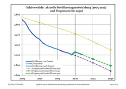 Recent Population Development and Projections (Population Development before Census 2011 (blue line); Recent Population Development according to the Census in Germany in 2011 (blue bordered line); Official projections for 2005-2030 (yellow line); for 2017-2030 (scarlet line); for 2020-2030 (green line)


|
|
|
References
[edit]- ^ Landkreis Elbe-Elster Wahl der Bürgermeisterin / des Bürgermeisters, accessed 1 July 2021.
- ^ "Bevölkerungsentwicklung und Bevölkerungsstandim Land Brandenburg Dezember 2022" (PDF). Amt für Statistik Berlin-Brandenburg (in German). June 2023.
- ^ Detailed data sources are to be found in the Wikimedia Commons.Population Projection Brandenburg at Wikimedia Commons
Towns and municipalities in Elbe-Elster | ||
|---|---|---|
|  | |
| International | |
|---|---|
| National | |
This Brandenburg location article is a stub. You can help Wikipedia by expanding it. |